

Images: Eumetsat (Click on images for larger view.)
The intense well developed cold front is approaching the Western Cape from the West and is expected to make landfall later today.
What can we expect from this cold front?
1. Severe Weather
2. Moderate to Heavy rain
3. Strong to Gale Force North Westerly Winds
4. Possible flooding
5. Thunderstorms and Lightning (Hail, ice rain and possible sleet.)
6. Very cold conditions
7. Snowfall
8. Poor to bad visibility due to Veld Fires
9. Rough seas
10. Storm Damage
Severe Weather
This is a well developed and intense cold front that is expected to bring-forth severe weather during the prescribed period. Reports from Pierre Tromp on Gough Island indicated that they experienced the first snowfall of this front earlier this week on the mountains. The public are advised that the above conditions (1-10) can be expected and the necessary precautionary measures need to be taken by the public to minimize the impact of the storm and the subsidiary events.
Moderate to Heavy rain


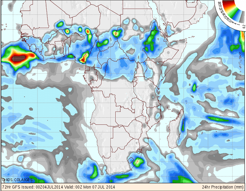
Images: NCEP (Click on images for larger view.)
Moderate to heavy rain is expected in areas of the Western-, Northern and Southern Cape. Heavy rain is expected in Cape Town and surrounding areas, Overberg, Cape Winelands and West Coast. Up to 50mm can be expected in these areas with moderate rain (1- 9mm) over other parts of the Western Cape, Northern Cape and Southern Cape.
Strong to Gale Force North Westerly Winds
Strong to Gale Force (45 - 65 km/h) gusty winds can be expected along the West Coast, Western-, Southern and Eastern Cape coastline. Strong to Near Gale Force (35 - 60 km/h) gusty winds can also be expected over parts of the interior. Wind damage is possible in areas.


Images: Wind Guru + Weather Forecast.com (Click on images for larger view.)
Possible flooding
Localized flooding is expected in parts of the Cape, Overberg, Cape Winelands and West Coast. Flooding of road and informal settlements is expected in these areas. Flooding, blocked drains and service disruptions can be reported to the Cape Towns City’s Call Centre on 0860 103 089. The local authorities of other regions should be contacted if assistance is needed. In the event of flooding do not try to cross flooded roads, ravines, rivers or streams. Turn around....do not drown!!
Thunderstorms and Lightning (Hail, ice rain and possible sleet.)
There is a 30% chance of thunderstorms preceding the front and even as the front is moving along. As we all should know by now with warm and cold air in circulation the possbility of hail, ice rain and possible sleet cannot be ruled out. So be on the lookout for this phenomena. It might just develop and unfold.
Very cold conditions
Very cold conditions (- to 0 Deg/C) is expected behind the cold front as cold air is moving in over the Western-, Southern-, and Northern Cape. Temperatures are expected to drop as the freezing levels lower to 1200 - 1500 meters. This will lead to conditions conducive for snowfall over parts of the mountains in the Northern Cape, Western Cape, Southern Cape and Eastern Cape.
Snowfall
Snow is expected over parts of the Northern-, Southern-, Eastern-, and Western Cape mountains. The following images display the areas were snowfall can be expected.


Images: Snow Forecast.com (Click on images for larger view.)
Poor to bad visibility due to Veld Fires
Poor to bad visibility can be expected as the risk for run-away veld fires increase with the high fire danger conditions in the interior. 131 fires were detected over the past 24 hours in South Africa. This figure is expected to increase as strong to gale force winds precedes the cold front. Please contact your nearest fire fighting unit, Working on Fire or Local Fire Fighting Service when fires are observed. The earlier a fire is detected to better the chances of extinguishing the fire.
Rough seas
With all the above "ingredients" the sea is surely to be churned up. Rough seas with wave heights of between 4 - 6 meters are expected along the coastal areas of the Northern Cape, Western Cape, Southern Cape, Eastern Cape and Kwazulu Natal. People living close to the high water mark should be on the lookout for rising water levels during high tides and possible storm surges.
Storm Damage
Storm damage is expected as a result of this intense cold front. If you observe any storm damage in your area, please forward details, images and description to @SAWXREP We need to keep the public informed at all times.
Finally: Do not underestimate any weather system. MSBWX will monitor this front closely and will bring you updates as this system moves across the country.
SAWXREP need your real time weather observations i.o.w. if you observe heavy rain, flooding, strong wind, rough seas, storm damage etc. Please inform the SAWXREP so that we in turn can keep the public informed. Tweet us at @SAWXREP or post on our Facebook timeline by clicking HERE. Do not assume that SAWXREP knows for certain that severe weather has occurred. Help us to spread the word about severe weather and NEVER assume that your weather observation report is not important. SAWXREP would like to hear from you.
- MSBWX + SAWXREP