Showing posts with label flash flooding. Show all posts

Wednesday, 25 March 2015

Opvolg/Fotos: #Meiringspoort weer oop vir verkeer

OUDTSHOORN NUUS - Meiringspoort is weer oop vir verkeer.
 
Die poort is gesluit nadat erge reën die rivier in vloed laat afkom het.
 
'n Greyhound-bus en verskeie ander voertuie het in die poort vasgesit.


Article and images: Oudtshoorn Courant (Click on images for larger view.)

Tuesday, 24 March 2015

Greyhound bus vasgekeer in Meiringspoort


08:17 (GMT+2), Tue, 24 March 2015  - OUDTSHOORN NUUS - Die Greyhound-bus waarop 18 mense laasnag in Meiringspoort buite Oudtshoorn vasgekeer was, sal vanoggend deur 'n insleepdiens verwyder word.

Die insittendes van die bus het deur vensters van die boonste verdieping geklim en op die krans geskuil toe die watervlak vinnig gestyg het.

Hulle kon teen middernag, nadat die water weer gesak het, terugklim in die bus waar hulle op nooddienste gewag het.

Twee polisielede en bestuurders van ten minste drie ander swaar voertuie was ook vasgekeer.

Die twee insittendes van 'n groen Golf, waaroor mense laasnag navraag gedoen het, is ook veilig. Dit blyk dat die motor naby die plek waar die bus en ander swaar voertuie vasgekeer is van die pad afgespoel is. Die insittendes is deur nooddienstewerkers gered. Een van die insittendes is in die hospitaal.

Volgens verkeersowerhede sal die poort nog 'n geruime tyd gesluit wees


22:48 (GMT+2), Mon, 23 March 2015 - OUDTSHOORN NUUS - Die Oudtshoorn Courant het pas verneem die bus-passasiers kon van die rotse afkom en terugklim in die bus nadat die watervlak heelwat gesak het.

Die nooddienste in De Rust het pas 'n vergadering gehou en besluit dis nog nie veilig om van De Rust se kant by die bus uit te kom nie.

Op hierdie stadium lyk dit asof Metro-nooddienste van Beaufort-Wes se kant af 'n beter kans het om by die bus uit te kom.

Die nooddienste het bevestig dat hulle vanaand heel aand op die toneel gaan bly totdat dit veilig is om die mense van die bus af te haal.

Meiringspoort sal beslis die res van die nag en waarskynlik heel dag môre gesluit wees.
21:53 (GMT+2), Mon, 23 March 2015 - OUDTSHOORN NUUS - Die Oudtshoorn Courant het onlangs sowat 1km vanaf De Rust saam met nooddienste tot by die eerste brug in Meiringspoort gery.

Die vlak van die rivier is sowat 'n meter bo oor die brug en ongeveer 35m breed.

Dit lyk asof die vlak die afgelope uur effens gesak het, maar nooddienswerkers kan steeds nie deur die drif gaan om by die vasgekeerde bus uit te kom nie.
Daar is vasgestel dat die bus by die laaste drif aan die Klaarstroom-kant van Meirngspoort vas.
Die mense op die bus het laat weet hulle kan noodligte sien wat van Beaufort-Wes se kant af na hulle kom, maar dis nog nie duidelik of daardie nooddienste by hulle kan uitkom nie.
Dis onduidelik of al 18 passasiers uit die bus is, maar volgens een van die Greyhound-personeel, wat via radio met nooddienswerkers in kontak is, het die watervlak gedaal en is almal veilig. 
21:13 (GMT+2), Mon, 23 March 2015 - OUDTSHOORN NUUS - Die Oudtshoorn Courant is op die oomblik op die toneel in Meiringspoort.

Die Grootrivier loop tans ongeveer 30m breed in volle vloed.

Daar is bevestig dat 9 van die 18 passasiers van die Greyhound-bus daarin geslaag het om op die bus se dak te klim en van die dak af tot op kranse. Hulle is buite gevaar maar is vasgekeer en nooddienswerkers kan nie by hulle uitkom nie. Die ander 9 passasiers is steeds in die bus.
Vier polisiemanne is ook vasgekeer.

Dit reën steeds.
20:47 (GMT+2), Mon, 23 March 2015 
Oudtshoorn - Nooddienste het pas by Meiringspoort aangekom nadat hulle in kennis gestel is dat 'n passasiersbus en verskeie ander voertuie in die poort vasgekeer is nadat die rivier in vloed afgekom het.
Die bus is in 'n drif vasgekeer en passasiers is besig om op die dak te klim. Nooddienswerkers sukkel om by die bus uit te kom as gevolg van die hoë watervlak.
Van die ander voertuie wat vasgekeer is, is 'n swaar vragmotor en 'n polisievoertuig.
'n Vragmotor het ook in die rivier omgeslaan. Die bestuurder is nie beseer nie.
Dit het intussen weer begin reën.
Die pas is gesluit en sal die hele nag gesluit bly. Motoriste moet Willowmore om ry vanaf De Rust.

- Oudtshoorn Courant

Wednesday, 25 February 2015

#SAWeather and #Disaster #Observations South Africa : 25 February 2015 04h00 SAST - MSBWX

Image: Via Traffic SA (Click on image for larger view.)

SAWS SEVERE WEATHER ALERTS: 
 
WARNINGS: -----Nil

WATCHES: -----Nil

SPECIAL WEATHER ADVISORIES: -----Nil

MSBWX National Severe Weather Observations: Parts of the Free State, Northern Cape and, Eastern Cape received welcome rain yesterday evening.  However Kimberley in the Northern Cape received more than they bargained for.  A cloudburst turned  streets into rivers yesterday afternoon after a severe storm hit the city at around 15h00.

Netwerk24 report: Die wolkbreuk, wat net ná 15:00 uitgesak het, het die stad in chaos gedompel en ’n groot kragonderbreking veroorsaak. ’n Mini-substasie het ook in Galeshewe ontplof. Huise van Beaconsfield tot Galeshewe is oorstroom, sypaadjies is weggespoel, tuine het in damme verander en strate het in riviere ontaard. ’n Woedende skare het in Colville saamgedrom nadat huise oorstroom is. Die Noord-Kaap-inkopiesentrum se parkeergarage was oorstroom. Verwarde honde het weens die swaar weer in die strate rondgehardloop. Alle elektriese spanne van die Sol Plaatje-munisipaliteit was op ’n gereedheidsgrondslag, het Sello Matsie, munisipale woordvoerder, Dinsdagaand gesê. Michael Netha, voorspeller by die Suid-Afrikaanse weerburo, het gesê teen 18:00 het sowat 77 mm reeds geval. Erge reën en donderweer het opnuut teen 19:00 begin.

Lees meer hier 


Images: Twitter (Click on image for larger view.)

MSBWX General Weather Observations:  Cool, warm to hot conditions expected today over parts of SA. Thunderstorms and rain showers can be expected in parts of Gauteng, Mpumalanga, Limpopo, Northern Cape, North West, Free State, Eastern Cape and Kwazulu Natal.

MSBWX National Disaster Observations:  The veld fire season is still continuing in the Western and Southern Cape.  Please be careful around open fires, throwing away of cigarette butts and equipment that can start a fire. Be fire wise!

For pictures and more info go to https://twitter.com/SAWXREP

NSRI National Warnings and News: ------Nil

- MSBWX, SAWXREP + SAWS


Wednesday, 18 February 2015

#SAWeather and #Disaster #Observations South Africa : 18 February 2015 04h00 SAST - MSBWX


SAWS SEVERE WEATHER ALERTS: 
 
WARNINGS: Extremely high fire danger conditions are expected over the interior of the Northern Cape, western parts of North West, western parts of the Free State as well as over the Central and Little Karoo of the Western Cape.  

WATCHES: ------Nil

SPECIAL WEATHER ADVISORIES: 1. Very hot weather will result in extremely uncomfortable conditions over the central and eastern interior of the Western Cape. 2. Extremely hot conditions are expected over the Ce ntral and Little Karoo of the Western Cape. 3. Heatwave conditions with persistently high temperatures are expected over Gauteng and eastern half of the North - West province from Thursday until Saturday.

MSBWX National Severe Weather Observations: Heavy rain, hail and flash flooding were observed early yesterday morning in parts of Gauteng.
Six houses were flooded when the Klein Jukskei River overflowed in Randpark Ridge and Fontainebleau at about 1am on 17 February.
It had been raining heavily during the night.
No one was hurt, but ER24 paramedics treated three people for trauma, said ER24 spokesperson Russel Meiring. (Images: Twitter and as indicated on each image.)


Read more: Randburg - Flooding damages six houses

MSBWX General Weather Observations:  Cool, warm to very hot conditions expected today over parts of SA. Thunderstorms and rain showers can be expected in parts of   Gauteng, Mpumalanga, North West,  Northern Cape,
Free State, Eastern Cape and Kwazulu Natal. 

MSBWX National Disaster Observations:  Veld fires are burning again in parts of SA.   (Images: Twitter and as indicated underneath the images) Please be careful around open fires, throwing away cigarette butts and equipment that can start a fire. Be fire wise!


NSRI National Warnings and News: ------Nil

- MSBWX, SAWXREP + SAWS 

Friday, 30 January 2015

#Flooding along the Shire River, #Mozambique and #Malawi


In January 2015, several bouts of heavy rain triggered widespread flooding in southern Africa. The Advanced Land Imager (ALI) on the EO-1 satellite captured this image of flooding along the Shire River in Malawi and Mozambique on January 26, 2015. See this gallery for more satellite imagery of flooding in southern Africa.
NASA Earth Observatory image by Jesse Allen, using EO-1 ALI data provided courtesy of the NASA EO-1 team.Caption by Adam Voiland.
Instrument(s): 
EO-1 - ALI - NASA

Saturday, 24 January 2015

#Flooding in #Mozambique


( Click on images for larger view)
Residents of Mozambique’s Zambezia province are accustomed to picking up their belongs and heading for higher ground during the wet season. But even by local standards, the onslaught in January 2015 has been unusual.
Weeks of heavy rainfall in December 2014 and January 2015 caused rivers in the province to swell. When a particularly strong tropical disturbance passed over Mozambique on January 14, 2015, the Licungo River, as well as other rivers in the region, began to flood. By January 20, the Licungo was higher than it had been since 1971. As of January 22, news media reported that floodwater had killed 86 Mozambicans, destroyed 11,000 homes, and displaced tens of thousands of people.
On January 17, 2015, the Moderate Resolution Imaging Spectroradiometer (MODIS) on NASA’s Terra satellite captured the top image, which shows flooding along the Licungo and other rivers in coastal Mozambique. Thick plumes of sediment-rich water are also visible in the Mozambique Channel. Though individual villages are not visible at MODIS’s spatial resolution, floodwaters have inundated dozens of villages. The lower image shows the same area on February 1, 2014.
When floods occur, satellites can do much more than provide natural-color imagery. For instance, researchers from the University of Colorado, NASA’s Jet Propulsion Laboratory, and NASA’s Goddard Space Flight Center publish near-real time maps of flooded areas as part of a project called the Flood Observatory. The scientists use data collected by MODIS, Landsat 8, and the European Space Agency’s Sentinel 1 to create the maps. For select locations, the researchers can also estimate river discharge based on data from microwave sounders on satellites such as AquaGCOM-W and TRMM. To learn more, visit the Flood Observatory’s resource page for this event.
  1. References and Related Reading

  2. allAfrica (2015, January 20) Current Conditions and Maximum Flood Extent, 2015 Flooding in Malawi and Southern Mozambique. Accessed January 22, 2015.
  3. Dartmouth Flood Observatory (2015, January 22) Mozambique: Licungo Dropping, but River Basin Still Flooded.Accessed January 22, 2015.
  4. ENCA (2015, January 21) IN PICTURES: Floods ravage Mozambique as thousands are cut off. Accessed January 22, 2015.
  5. Masters, J. via Weather Underground (2015, January 15) Floods Kill at Least 260 in Malawi, Mozambique, and Madagascar. Accessed January 22, 2015.
  6. Jacarandafm (2015, January 21) VIDEO: Mozambique Flood Disaster. Accessed January 22, 2015.
  7. ReliefWeb (2015, January 19) Flood Waters Over Zambezia Province, Mozambique (as of 19 Jan 2015). Accessed January 22, 2015.
  8. ReliefWeb (2015, January) Southern Africa: Floods – Jan 2015. Accessed January 22, 2015.
NASA images courtesy the MODIS Rapid Response Team at NASA GSFC. Caption by Adam Voiland.
Instrument(s): 
Terra - MODIS - NASA

Wednesday, 21 January 2015

#Flooding in #Madagascar #cyclone #Tropicalstorm


tropical disturbance that had already swamped southern Africa with rain strengthened into a tropical storm as it passed over the Mozambique Channel on January 15, 2015. When tropical storm Chedza passed over Madagascar the next day, it brought lashing winds and heavy rains that killed at least 13 people, destroyed or damaged more than 3,000 homes, and displaced 9,500 people.
The Operational Land Imager (OLI) on Landsat 8 captured this image of flooding along the Tsiribihina River on January 20, 2015. For comparison, the lower image shows the same area on December 3, 2014. Turn on the comparison tool to slide between the two images. In the more recent image, brown, sediment-rich floodwater spills across the river delta and into the Mozambique Channel.
Several settlements along the Tsiribihina River—including Belo Tsiribihina and Masoarivo—appear to be at least partially flooded. The same weather system produced widespread flooding in Mozambique and Malawi. For a broader view of flooding on the Tsiribihina River, you can view imagery captured by the Moderate Resolution Imaging Spectroradiometer (MODIS) on NASA’s Terra satellite on the Worldview browser.
NASA Earth Observatory images by Joshua Stevens, using Landsat data from the U.S. Geological Survey. Caption by Adam Voiland.
Instrument(s): 
Landsat 8 - OLI

Saturday, 17 January 2015

#SAWeather and #Disaster #Observations South Africa : 17 January 2015 04h00 SAST - MSBWX

SAWS SEVERE WEATHER ALERTS: 
 
WARNINGS: -------Nil 

WATCHES: ----Nil 

SPECIAL WEATHER ADVISORIES: ----Nil 

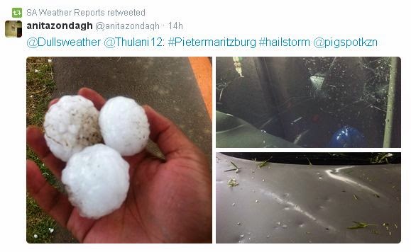
MSBWX National Severe Weather Observations:  What an interesting weather day yesterday.  It all started with a cold front meeting up with warm air that resulted in severe weather being experienced in areas of the country.  Provinces that bear the brunt were Gauteng, Western Cape, Eastern Cape and Kwazulu Natal. Large hail, intense lightning, heavy rain, gale force wind and flooding were reported. Provisional storm damage reports were received from Muizenberg, Port Elizabeth,  Uthungulu, Nkandla, Nxalala and Pietermatizburg. Several people were injured and houses and cars were damaged. Two people were struck by lightning in Kwazulu Natal.  Golf ball and egg size hail caused damage in Pietermaritzburg.  Images: Twitter and various observers as depicted in the images. (Click on images for larger view.)


Yesterday (16/1/2015) we experienced a classic weather phenomena were cold air met hot air, turns into severe weather and the above is the end result.  SAWXREP monitored temperatures throughout the day and it was obvious that severe weather were to be expected as temperatures dropped sharply as the front moved in over areas while hot and humid conditions were measured ahead of the cold front. Needless to say that all the other normal "ingredients" had to be present to form severe thunderstorms.


MSBWX General Weather Observations:  Cool, warm to hot conditions expected today over parts of SA. Thunderstorms and rain showers can be expected in parts of  Gauteng, Mpumalanga, Limpopo, North West and Free State. Isolated showers and rain can be expected in the Eastern Cape and Kwazulu Natal. 

MSBWX National Disaster Observations:  Several veld fires were again burning in parts of the Western Cape yesterday. 


NSRI National Warnings:------ Nil

- MSBWX + SAWXREP + SAWS