Showing posts with label Storm Damage. Show all posts

Saturday, 17 January 2015

#SAWeather and #Disaster #Observations South Africa : 17 January 2015 04h00 SAST - MSBWX

SAWS SEVERE WEATHER ALERTS: 
 
WARNINGS: -------Nil 

WATCHES: ----Nil 

SPECIAL WEATHER ADVISORIES: ----Nil 

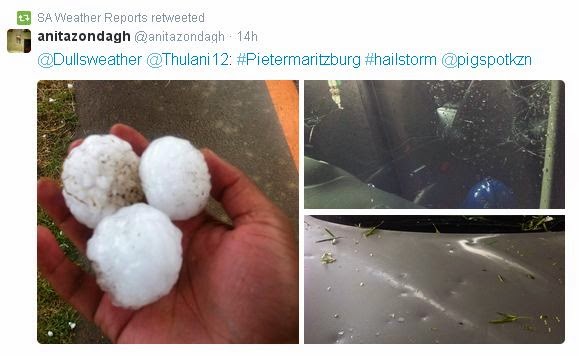
MSBWX National Severe Weather Observations:  What an interesting weather day yesterday.  It all started with a cold front meeting up with warm air that resulted in severe weather being experienced in areas of the country.  Provinces that bear the brunt were Gauteng, Western Cape, Eastern Cape and Kwazulu Natal. Large hail, intense lightning, heavy rain, gale force wind and flooding were reported. Provisional storm damage reports were received from Muizenberg, Port Elizabeth,  Uthungulu, Nkandla, Nxalala and Pietermatizburg. Several people were injured and houses and cars were damaged. Two people were struck by lightning in Kwazulu Natal.  Golf ball and egg size hail caused damage in Pietermaritzburg.  Images: Twitter and various observers as depicted in the images. (Click on images for larger view.)


Yesterday (16/1/2015) we experienced a classic weather phenomena were cold air met hot air, turns into severe weather and the above is the end result.  SAWXREP monitored temperatures throughout the day and it was obvious that severe weather were to be expected as temperatures dropped sharply as the front moved in over areas while hot and humid conditions were measured ahead of the cold front. Needless to say that all the other normal "ingredients" had to be present to form severe thunderstorms.


MSBWX General Weather Observations:  Cool, warm to hot conditions expected today over parts of SA. Thunderstorms and rain showers can be expected in parts of  Gauteng, Mpumalanga, Limpopo, North West and Free State. Isolated showers and rain can be expected in the Eastern Cape and Kwazulu Natal. 

MSBWX National Disaster Observations:  Several veld fires were again burning in parts of the Western Cape yesterday. 


NSRI National Warnings:------ Nil

- MSBWX + SAWXREP + SAWS 

Friday, 9 January 2015

#SAWeather and #Disaster #Observations South Africa : 9 January 2015 04h00 SAST - MSBWX

SAWS SEVERE WEATHER ALERTS: 
 
WARNINGS: Extremely high fire danger conditions are expected over the eastern and central parts of the Northern Cape and extreme western parts of the North West province. 

WATCHES: -----Nil 

SPECIAL WEATHER ADVISORIES: Hot and humid weather will result in extremely uncomfortable conditions in places in the Lowveld of Limpopo.  

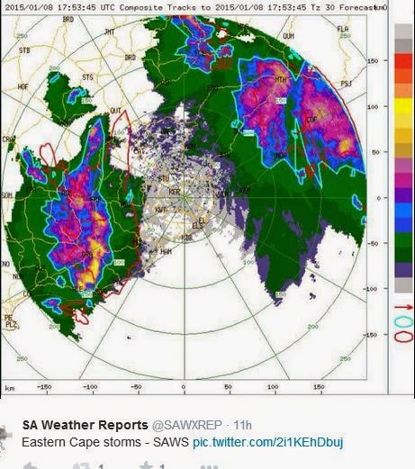
MSBWX National Severe Weather Observations:  Damaging thunderstorms and severe lightning lashed parts of the Eastern Cape yesterday afternoon and evening. 13 homes were damaged when a  severe storm hit Bedford in the Eastern Cape. Roofs were blown of and houses collapsed. Several people were injured and taken to hospital.  Flooding was again observed in Gauteng after heavy rain.  


Opdatering: Inwoners van Phola Park by Bedford in die Oos-Kaap herstel nog nadat `n swaar storm die woongebied getref het. Minstens dertien huise is beskadig en een het heeltemal ineengestort. Twee mense is in die hospitaal opgeneem nadat hul huise inmekaargeval het. Amptenare van die Nxuba-munisipaliteit is besig om die skade te bepaal. Die gemeenskap van Mbozisa het ook deurgeloop. Die dakke van verskeie huise is afgewaai. Die oeste van boere is ook beskadig. - RSG Nuus


In another incident Two women sustained moderate injuries and a man minor injuries when a tree collapsed on a taxi in West Street, Pietermaritzburg, yesterday. It is understood that the taxi driver was driving down the road during heavy downpour. The tree fell over and landed on the taxi leaving two women, in their 50s, trapped in the vehicle. When ER24 paramedics, and other services, arrived on scene, they found the tree lying across the windscreen and the front portion of the taxi’s roof. Patients were apparently flung to the back of the taxi when the incident occurred leaving two of them entrapped. The seats were pushed further down to free their legs which were wedged. Paramedics treated the patients and transported them to the Edendale Hospital. Local authorities were on scene. - ER24


MSBWX General Weather Observations:  Cool, warm to very hot conditions expected today over parts of SA. Thunderstorms and rain showers can be expected in parts of  Gauteng, Mpumalanga, Limpopo, North West, Northern Cape, Western Cape, Free State, Eastern Cape and Kwazulu Natal.  

MSBWX National Disaster Observations:  Several veld fires were again burning in parts of the Western Cape yesterday.  However fire fighting services quickly contained the fires.  


All images: Twitter and as mentioned in the images.

NSRI National Warnings:------ Nil

- MSBWX + SAWXREP + SAWS

Saturday, 27 December 2014

Update 2: #SevereWeather, #HeavyRain #Flashflooding expected during the period 26 - 31 December 2014 in SA

This morning we have a more defined system over the country that is already depositing heavy rain in areas.


Reports of heavy rain, flooding and thunderstorms were received  this morning from East London. Tropical moist air is currently moving in over parts of the country. A fairly intense cloud base is currently situated over parts of the North West and central Free State.


Further heavy rain (>50mm), severe thunderstorms with possible hail and flooding are expected for the above period over parts of Gauteng, Limpopo, North West, Free State, Mpumalanga and the Eastern Cape.


Severe weather is expected with damaging results if this system intensifies further. A word of advise to holidaymakers near rivers, low water bridges, ravines, estuaries, low lying area and areas prone to flooding or flash flooding: Be on high alert for the above period (27 - 31 December 2014)

What can we expect from this system:
1. Always the possibility of Severe Weather
2. Moderate to heavy rain (50mm or more in places)
3. Strong winds
4. Possibility of Flooding or flash flooding
5. Colder weather conditions
6. Possible Severe thunderstorms
7. Possible Hail
8. Possible storm or flood damage

Finally: As always do not underestimate any weather system. MSBWX will monitor this system closely and will bring you updates as this system moves across the country.

SAWXREP need your real time weather observations i.o.w. if you observe heavy rain, flooding, strong wind, rough seas, storm damage etc. Please inform the SAWXREP so that we in turn can keep the public informed. Tweet us at @SAWXREP . Do not assume that SAWXREP knows for certain that severe weather has occurred. Help us to spread the word about severe weather and NEVER assume that your weather observation report is not important.

SAWXREP would like to hear from you.

Images: Eumetsat, Weather Underground, NCEP, SAT24 (Click on images for larger view.)

 - MSBWX + SAWXREP


Monday, 25 August 2014

Approaching Cold Fronts: Western-, Northern-, Eastern-, and Southern Cape 25 - 30 August 2014

Predictions charts reflect a series of cold fronts likely to impact the Western- ,  Northern-, Southern-  and Eastern Cape during the forecast period.  The first cold front is expected to make landfall later tonight (25 August 2014) while the second front should reach the country early Wednesday (27 July 2014) morning.


The SAWS has not issued any warnings as yet.

What can we expect from these cold fronts:

1.  Always the possibility of Severe Weather
2.  Moderate to heavy rain
3.  Strong to near gale force winds
4.  Possible Flooding
5.  Cold weather conditions
6.  Snowfalls over the high mountains
7.  Veld fires
8.  Rough Seas
9.  Possible storm damage

Severe Weather

The second front is a well developed  and intense weather system that is expected to bring-forth severe weather during the prescribed period.  The public are advised that the above conditions (1- 9)  can be expected and the necessary precautionary measures need to be taken by the public to minimize the impact of the storm and the subsidiary events.


Moderate to Heavy rain


Moderate to heavy rain is expected in areas of the Western Cape.  Heavy rain is expected in Cape Town and surrounding areas, Overberg, Cape Winelands and West Coast.  Up to 50mm can be expected in these areas with moderate rain (1- 25mm) over other parts of the Western Cape, Northern Cape and Southern- and Eastern Cape.

Strong to Gale Force Winds


Strong to Gale Force (45 - 75 km/h) gusty South Westerly to Westerly winds can be expected along the West Coast, Western-, Southern and Eastern Cape coastline. Strong to Near Gale Force (35 - 80 km/h) gusty winds can also be expected over parts of the interior. Wind damage is possible in areas.

Possible flooding

Localized flooding is expected in parts of the Cape Metropole, Overberg, Cape Winelands and West Coast. Flooding of roads and informal settlements is expected. Flooding, blocked drains and service disruptions can be reported to the Cape Towns City’s Call Centre on 0860 103 089. The local authorities of other regions should be contacted if assistance is needed.   In the event of flooding do not try to cross flooded roads, ravines, rivers or streams.  Turn around....do not drown!!

Very cold conditions

Very cold conditions (- to 0 Deg/C) is expected behind the cold front as cold air is  moving in over the Western-, Southern-, Eastern and Northern Cape.  Temperatures are expected to drop as the freezing levels lower to 1200 - 1500 meters. With enough moisture and dropping freezing levels snowfalls are expected over parts of the mountains in the Northern-, Western-, Eastern- and Southern Cape.


Snowfall


Snow is expected over parts of the Northern-, Southern-, Eastern - and Western Cape mountains.

Snow Forecast  by Snow Report SA:  

A cold weather system should hit the WC from late Tuesday, early Wednesday morning, with the expectation of snow-fall on Wednesday afternoon.  The snow will continue in certain parts of WC (Ceres, Citrusdal, Stellenbosch, Montagu and Swellendam) throughout Thursday. Up to 10 cm or more is expected in certain mountain ranges of the WC, including Matroosberg.

The cold front will continue to move across the country into the Northern Cape on Wednesday night, Thursday morning and further across into areas such as Hogsback. We can expect snow-fall in the Eastern Cape on Thursday going into Friday morning. The snow should also extend right into Southern and Central Lestho during Thursday, moving all the way up to Northern Lesotho and the Sani Pass area later in the day and early hours of Friday morning. Snowfalls into the KZN Midlands seem unlikely at this point due to a lack of moisture.


Raging Veld Fires

Poor to bad visibility can be expected as the risk for run-away veld fires increase with the high fire danger conditions in parts of the Western Cape (Southern Cape, Breede River Valley, Cental and Little Karoo) and the interior of  the country.

457 fires were detected over the past 24 hours in South Africa.  This figure is expected to increase as strong to gale force winds precedes the cold front.  Please contact your nearest fire fighting unit, Working on Fire or Local Fire Fighting Service when fires are observed.  The earlier a fire is detected to better the chances of extinguishing the fire.

Rough seas

With all the above "ingredients" the sea is surely to be churned up.  Rough seas with wave heights of between 4 - 6 meters are expected along the coastal areas of the Northern Cape, Western Cape, Southern Cape and  Eastern Cape

Storm Damage

Storm damage is expected as a result of this intense cold front.  If  you observe any storm damage in your area, please forward details, images and description to  @SAWXREP  We need to keep the public informed at all times.

Finally:  As always do not underestimate any weather system.  MSBWX will monitor this front closely and will bring you updates as this system moves across the country. 

SAWXREP need your real time weather observations i.o.w. if you observe heavy rain, flooding, strong wind, rough seas, storm damage etc. Please inform the SAWXREP so that we in turn can keep the public informed. Tweet us at @SAWXREP or post on our Facebook timeline by clicking HERE. Do not assume that SAWXREP knows for certain that severe weather has occurred. Help us to spread the word about severe weather and NEVER assume that your weather observation report is not important.  SAWXREP would like to hear from you.

Images: Eumetsat, SAWS, NCEP, Weather Forecast.com, SnowForecast.com and CSIR - AFIS (Click on images for larger view.)

- MSBWX + SAWXREP 

Wednesday, 20 August 2014

Approaching Cold Fronts: Western-, Northern-, Eastern-, and Southern Cape 20 - 23 August 2014

Predictions charts reflect  a series of cold fronts likely to impact the Western- ,  Northern-, Southern-  and Eastern Cape during the forecast period.  The first cold front is expected to make landfall later today (20 August 2014) followed by the other fronts.

No warnings were issued by the SAWS as yet.

What can we expect from these cold fronts:

1.  Always the possibility of Severe Weather
2.  Light to moderate rain
3.  Strong to near gale force winds
4.  Cold weather conditions
5.  Light snowfalls over the high mountains
6.  Veld fires
7.  Wave Heights
8.  Possible storm damage


Severe Weather

This is a moderate intense weather system. However one can never rule out the possibility of  the approaching cold fronts turning into severe weather.  The public are advised that the above conditions (1- 8)  can be expected and the necessary precautionary measures need to be taken by the public to minimize the impact of the storm and the subsidiary events.

Light to Moderate rain 

Light to moderate  rain (1 - 12 mm ) is expected in areas of the Western Cape, West Coast, Southern and Eastern Cape coastal belt.  Prefrontal rain and thundershowers is expected to fall in parts of the Western Cape, Eastern Cape, Kwazulu Natal, Northern Cape, Lesotho, Free State and North West.

Strong to near gale force winds

Strong  (45 - 50 km/h) gusty North Westerly to Westerly winds can be expected along the West Coast, Western-, Southern and Eastern Cape coastline. Strong to Near Gale Force (35 - 80 km/h) gusty winds can also be expected over parts of the interior.


Cold conditions

Cold conditions is expected behind the cold front as cold air is  moving in over the Western-, Southern-, and Northern Cape.  Temperatures are expected to drop as the freezing levels lower.

Snowfall

Snow is expected over parts of the Northern-  and possibly the Western Cape mountains. 

With enough moisture and dropping freezing levels light snowfalls are expected over parts of the mountains in the Northern and possibly the Western Cape.


Raging Veld Fires


Poor to bad visibility can be expected as the risk for run-away veld fires increased in the last couple of days
  231 fires were detected over the past 24 hours in South Africa.  This figure is expected to increase as strong to gale force winds precedes the cold front.  Please contact your nearest fire fighting unit, Working on Fire or Local Fire Fighting Service when fires are observed.  The earlier a fire is detected to better the chances of extinguishing the fire.

Wave Heights

With all the above "ingredients" the sea is surely to be churned up a bit.  Wave heights of between 3 - 4 meters are expected along the coastal areas of the Northern Cape, Western Cape, Southern Cape and  Eastern Cape

Storm Damage

Storm damage might result due to the cold front.  If  you observe any storm damage in your area, please forward details, images and description to  @SAWXREP  We need to keep the public informed at all times.

Finally:  As always do not underestimate any weather system.  MSBWX will monitor these cold fronts closely and will bring you updates as this system moves across the country. 

SAWXREP need your real time weather observations i.o.w. if you observe heavy rain, flooding, strong wind, rough seas, storm damage etc. Please inform the SAWXREP so that we in turn can keep the public informed. Tweet us at @SAWXREP or post on our Facebook timeline by clicking HERE. Do not assume that SAWXREP knows for certain that severe weather has occurred. Help us to spread the word about severe weather and NEVER assume that your weather observation report is not important.  SAWXREP would like to hear from you.

Images: Eumetsat, NCEP, Weather Forecast.com, Snow Forecast.com, Windguru and NASA (Click on images for larger view.)


- MSBWX + SAWXREP