
Thursday, 7 May 2015
Possible 24 Hour #Rainfall #Prediction South Africa - 1stweather
Wednesday, 6 May 2015
Plume in Moreton Bay, Australia
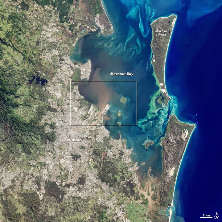

On May 3, after the storm had passed, the Operational Land Imager (OLI) on Landsat 8 acquired this view of a plume from the Brisbane River entering Moreton Bay. The second image shows a close-up view of the area.
Flood waters usually contain elevated levels of sediment and colored dissolved organic matter (CDOM), explained NASA ocean color scientist Lachlan McKinna. Sediment tends to scatter red light, and CDOM absorbs blue light. As a result, a brown color is visible at the river’s mouth where these two optical phenomena work in concert.
“However, as you move farther away from the river mouth, the coarser sediments tend to settle to the bottom but the CDOM still hangs around in the water column absorbing blue light,“ McKinna said. “I expect it is elevated levels of CDOM causing the yellow-green patches in Moreton Bay.”
The May storm followed a disturbance that brought destructive winds and floods to New South Wales from April 20–22. And Australia’s west coast did not go unscathed, as rainfall from tropical cyclone Quang drenched the region.
Watch this animation, based on data from the Integrated Multi-satellite Retrievals for GPM (IMERG), to see rainfall accumulate around the Australian coast from April 28 to May 3.
References and Related Reading
- Australian Government Bureau of Meteorology (2015, May 1) Northern NSW to feel the brunt of East Coast Low Overnight. Accessed May 5, 2015.
- NASA Earth Observatory (2015, April 21) Storm Hits New South Wales, Australia.
- Precipitation Measurement Missions (2015, May 4) NASA IMERG Sees Australia’s Bicoastal Rainfall. Accessed May 5, 2015.
- Reuters (2015, May 2) Flash floods kill five as torrential rains hit Australia’s east coast. Accessed May 5, 2015.
NASA Earth Observatory image by Jesse Allen, using Landsat data from the U.S. Geological Survey. Caption by Kathryn Hansen.
- Instrument(s):
- Landsat 8 - OLI
#Weather and #Disaster #Observations Western Cape : 5 May 2015 04h00 SAST - MSBWXB
SEVERE WEATHER ALERTS:
WARNINGS: -----Nil
WATCHES: ------Nil
SPECIAL WEATHER ADVISORIES: -------Nil
MOSSEL BAY REAL TIME WEATHER OBSERVATION:
06h30 - 7/8 Cloud. No Wind. 12 Deg/C. No Rain. 8 mm rain measured at Heiderand Mossel Bay (Period: 5 - 6 May 2015)
WEATHER FORECAST: WESTERN CAPE:
Cloudy along the south coast and eastern interior for the first half of the day, otherwise partly cloudy and cool. The wind along the coast will be moderate to fresh westerly to south - westerly along the south coast,otherwise fresh to strong southerly to south - easterly. The expected UVB sunburn index: High
For real live updates follow @MSBWXB on Twitter.
- MSBWX + SAWS
WARNINGS: -----Nil
WATCHES: ------Nil
SPECIAL WEATHER ADVISORIES: -------Nil
MOSSEL BAY REAL TIME WEATHER OBSERVATION:
06h30 - 7/8 Cloud. No Wind. 12 Deg/C. No Rain. 8 mm rain measured at Heiderand Mossel Bay (Period: 5 - 6 May 2015)
WEATHER FORECAST: WESTERN CAPE:
Cloudy along the south coast and eastern interior for the first half of the day, otherwise partly cloudy and cool. The wind along the coast will be moderate to fresh westerly to south - westerly along the south coast,otherwise fresh to strong southerly to south - easterly. The expected UVB sunburn index: High
DISASTER OBSERVATION: WESTERN CAPE: Nil
For real live updates follow @MSBWXB on Twitter.
- MSBWX + SAWS
1 – 3 Day #WeatherForecast Summary: #SouthernCape / #GardenRoute Area - Weather-Forecast

George 1 – 3 Day Weather Forecast Summary: Mostly dry. Warm (max 24°C on Fri afternoon, min 13°C on Wed morning). Wind will be generally light.
Knysna 1 – 3 Day Weather Forecast Summary: Mostly dry. Warm (max 24°C on Fri night, min 14°C on Wed morning). Mainly fresh winds.
Plettenberg Bay 1 – 3 Day Weather Forecast Summary: Mostly dry. Warm (max 24°C on Fri night, min 14°C on Wed morning). Mainly fresh winds.
Oudtshoorn 1 – 3 Day Weather Forecast Summary: Mostly dry. Warm (max 26°C on Fri afternoon, min 11°C on Wed morning). Wind will be generally light.
Riversdale 1 – 3 Day Weather Forecast Summary: Mostly dry. Warm (max 27°C on Fri afternoon, min 13°C on Wed morning). Wind will be generally light.
- Weather Forecast.com
#WeatherSatellite Image South Africa: 6 May 2015 05h00 SAST -Eumetsat

Latest Sea Level #SynopticChart South Africa: 5 May 2015 18:00 - SAWS

Image: SAWS (Click on image for larger view.)
Possible 24 Hour #Rainfall #Prediction South Africa - 1stweather

Tuesday, 5 May 2015
Landslide in Langtang Valley #Nepal #Earthquake #Landslide


While cloudy conditions have hampered satellite observations of Nepal since the earthquake, the Operational Land Imager (OLI) on Landsat 8 captured a clear view on April 30, 2015. A mixture of snow, ice, and debris—which originated in snowfields on the slopes above Langtang—slid toward the Langtang River and buried the village.
Walter Immerzeel and Philip Kraaijenbrink, members of a group of volunteer scientists with expertise in remote sensing, were the first to identify and analyze the landslide using Landsat 8. “The Langtang River was completely covered by the deposit that buried Langtang Village, but there is no evidence yet of a lake forming behind the blockage,” the scientists noted on their Mountain Hydrology website. “This may indicate that the water has found its way through the debris, snow, and ice.” This is significant because rivers damned with landslide debris can back up and lead to destructive downstream floods if the natural dam fails.
Turn on the image comparison tool to see the landslide debris cover Langtang and the Langtang River.
References and Related Reading
- Barnett R. (2015, April 29) Nepal Quake: Report on situation in Langtang, April 28, from Austin Lord. Accessed May 1, 2015.
- Mountain Hydrology Langtang village avalanche. Accessed May 1, 2015.
- Mountain Hydrology Landsat 8 reveals extent of earthquake disaster in Langtang Valley. Accessed May 1, 2015.
- Nepali Times “Langtang is gone.” Accessed May 1, 2015.
- Petley, D. via The Landslide Blog (2015, April 29) Landslides in Langtang during and after the Nepal earthquake. Accessed May 1, 2015.
- Time (2015, April 30) Americans Stranded in Nepal Mountains for 5 Days Tell Their Story of Survival. Accessed May 1, 2015.
NASA Earth Observatory images by Joshua Stevens, using Landsat data from the U.S. Geological Survey.
Caption by Adam Voiland. Thanks to Walter Immerzeel and Philip
Kraaijenbrink for help in locating the Landsat data.
- Instrument(s):
- Landsat 8 - OLI
#Weather and #Disaster #Observations Western Cape : 5 May 2015 04h00 SAST - MSBWXB

NO WARNINGS, WATCHES OR ADVISORIES AVAILABLE ON THE SAWS WEBSITE THIS MORNING.
WARNINGS: -----Nil
WATCHES: ------Nil
SPECIAL WEATHER ADVISORIES: -------Nil
MOSSEL BAY REAL TIME WEATHER OBSERVATION:
06h30 - 7/8 Cloud. No Wind. 16 Deg/C. No Rain.
WEATHER FORECAST: WESTERN CAPE:
Cloudy with light rain along the south and southwest coast, otherwise partly cloudy and cool but warm over the interior and west coast. The wind along the coast will be moderate to fresh westerly to southwesterly. The expected UVB Sunburn Index: Moderate
DISASTER OBSERVATION: WESTERN CAPE: Nil
For real live updates follow @MSBWXB on Twitter.
- MSBWX + SAWS
1 – 3 Day #WeatherForecast Summary: #SouthernCape / #GardenRoute Area - Weather-Forecast

George 1 – 3 Day Weather Forecast Summary: Light rain (total 4mm), mostly falling on Tue afternoon. Very mild (max 19°C on Tue afternoon, min 13°C on Tue night). Winds decreasing (fresh winds from the SW on Tue afternoon, calm by Wed night).
Knysna 1 – 3 Day Weather Forecast Summary: Light rain (total 3mm), mostly falling on Tue night. Very mild (max 19°C on Tue morning, min 14°C on Tue night). Winds decreasing (strong winds from the WSW on Tue afternoon, calm by Thu morning).
Plettenberg Bay 1 – 3 Day Weather Forecast Summary: Light rain (total 3mm), mostly falling on Tue night. Very mild (max 19°C on Tue morning, min 14°C on Tue night). Winds decreasing (strong winds from the WSW on Tue afternoon, calm by Thu morning).
Oudtshoorn 1 – 3 Day Weather Forecast Summary: Some drizzle, heaviest during Tue night. Warm (max 21°C on Thu afternoon, min 11°C on Wed morning). Wind will be generally light.
Riversdale 1 – 3 Day Weather Forecast Summary: Light rain (total 3mm), mostly falling on Tue afternoon. Warm (max 21°C on Thu afternoon, min 12°C on Thu morning). Winds decreasing (fresh winds from the SW on Tue afternoon, calm by Wed night).
- Weather Forecast.com
#WeatherSatellite Image South Africa: 5 May 2015 05h00 SAST -Eumetsat

Latest Sea Level #SynopticChart South Africa: 4 May 2015 18:00 - SAWS

Image: SAWS (Click on image for larger view.)
Possible 24 Hour #Rainfall #Prediction South Africa - 1stweather

Monday, 4 May 2015
Tsiribihina River, #Madagascar

Delta distributaries (channels and streams) have two morphologies: large and relatively straight or small and highly contorted. In the photo, brown sediment has been stirred up by heavy rains; when it reaches the sea, it is swept north (to the left in this image) by local ocean currents. Clearer blue water is visible to the lower right (south). Over thousands of years, the sediment supplied by the river has been shaped by waves into beach ridges along the shoreline. Those ridges appear as many parallel lines, with each line representing a prior coastline on this fast-changing (geologically speaking) coast. The oldest coastline lies furthest inland.
Four cyclones hit Madagascar in the first four months of 2015. Heavy floods followed a mid-January storm and affected not only the 50 kilometer (31 mile) shoreline of the delta but also the lower 75 kilometers (47 miles) of the river.
Astronaut photograph ISS043-E-101832
was acquired on April 12, 2015, with a Nikon D4 digital camera using a
1150 millimeter lens, and is provided by the ISS Crew Earth Observations
Facility and the Earth Science and Remote Sensing Unit, Johnson Space
Center. The image was taken by a member of the Expedition 43 crew. The image has been cropped and enhanced to improve contrast, and lens artifacts have been removed. The International Space Station Program supports the laboratory as part of the ISS National Lab
to help astronauts take pictures of Earth that will be of the greatest
value to scientists and the public, and to make those images freely
available on the Internet. Additional images taken by astronauts and
cosmonauts can be viewed at the NASA/JSC Gateway to Astronaut Photography of Earth. Caption by M. Justin Wilkinson, Texas State University, Jacobs Contract at NASA-JSC.
- Instrument(s):
- ISS - Digital Camera
#Weather and #Disaster #Observations Western Cape : 4 May 2015 04h00 SAST - MSBWXB
SEVERE WEATHER ALERTS:
WARNINGS: -----Nil
WATCHES: ------Nil
SPECIAL WEATHER ADVISORIES: -------Nil
MOSSEL BAY REAL TIME WEATHER OBSERVATION:
06h30 - 7/8 Cloud. No Wind. 14 Deg/C. No Rain.
WEATHER FORECAST: WESTERN CAPE:
Cloudy with light rain along the south and southwest coast, otherwise partly cloudy and cool but warm over the interior and west coast. The wind along the coast will be moderate to fresh westerly to southwesterly. The expected UVB Sunburn Index: Moderate
For real live updates follow @MSBWXB on Twitter.
- MSBWX + SAWS
WARNINGS: -----Nil
WATCHES: ------Nil
SPECIAL WEATHER ADVISORIES: -------Nil
MOSSEL BAY REAL TIME WEATHER OBSERVATION:
06h30 - 7/8 Cloud. No Wind. 14 Deg/C. No Rain.
WEATHER FORECAST: WESTERN CAPE:
Cloudy with light rain along the south and southwest coast, otherwise partly cloudy and cool but warm over the interior and west coast. The wind along the coast will be moderate to fresh westerly to southwesterly. The expected UVB Sunburn Index: Moderate
DISASTER OBSERVATION: WESTERN CAPE: Nil
For real live updates follow @MSBWXB on Twitter.
- MSBWX + SAWS
1 – 3 Day #WeatherForecast Summary: #SouthernCape / #GardenRoute Area - Weather-Forecast

George 1 – 3 Day Weather Forecast Summary: Light rain (total 3mm), mostly falling on Tue afternoon. Warm (max 22°C on Mon afternoon, min 12°C on Tue night). Winds decreasing (fresh winds from the SW on Tue afternoon, calm by Wed night).
Knysna 1 – 3 Day Weather Forecast Summary: Light rain (total 2mm), mostly falling on Tue afternoon. Warm (max 21°C on Mon afternoon, min 14°C on Tue night). Winds increasing (calm on Mon night, strong winds from the WSW by Tue afternoon).
Plettenberg Bay 1 – 3 Day Weather Forecast Summary: Light rain (total 2mm), mostly falling on Tue afternoon. Warm (max 21°C on Mon afternoon, min 14°C on Tue night). Winds increasing (calm on Mon night, strong winds from the WSW by Tue afternoon).
Oudtshoorn 1 – 3 Day Weather Forecast Summary: Some drizzle, heaviest during Tue night. Warm (max 24°C on Mon afternoon, min 11°C on Tue night). Wind will be generally light.
Riversdale 1 – 3 Day Weather Forecast Summary: Light rain (total 2mm), mostly falling on Tue afternoon. Warm (max 25°C on Mon afternoon, min 12°C on Tue night). Wind will be generally light.
#WeatherSatellite Image South Africa: 4 May 2015 05h00 SAST -Eumetsat

Latest Sea Level #SynopticChart South Africa: 3 May 2015 18:00 - SAWS

Image: SAWS (Click on image for larger view.)
Possible 24 Hour #Rainfall #Prediction South Africa - 1stweather

Sunday, 3 May 2015
#Weather and #Disaster #Observations Western Cape : 3 May 2015 04h00 SAST - MSBWXB
SEVERE WEATHER ALERTS:
WARNINGS: -----Nil
WATCHES: ------Nil
SPECIAL WEATHER ADVISORIES: -------Nil
MOSSEL BAY REAL TIME WEATHER OBSERVATION:
09h00 - Clear Skies. No Wind. 17 Deg/C. No Rain.
WEATHER FORECAST: WESTERN CAPE:
Morning fog patches along the coast, otherwise partly cloudy and cool to warm but fine over the north - eastern interior. Light rain in places in evening along the southwest coast. The wind along the coast will be light ot moderate southerly along the west coast, otherwise light to moderate north - westerly, becoming moderate to fresh westerly to south - westerly along the south coast by afternoon. The expected UVB sunburn Index: Moderate
For real live updates follow @MSBWXB on Twitter.
- MSBWX + SAWS
WARNINGS: -----Nil
WATCHES: ------Nil
SPECIAL WEATHER ADVISORIES: -------Nil
MOSSEL BAY REAL TIME WEATHER OBSERVATION:
09h00 - Clear Skies. No Wind. 17 Deg/C. No Rain.
WEATHER FORECAST: WESTERN CAPE:
Morning fog patches along the coast, otherwise partly cloudy and cool to warm but fine over the north - eastern interior. Light rain in places in evening along the southwest coast. The wind along the coast will be light ot moderate southerly along the west coast, otherwise light to moderate north - westerly, becoming moderate to fresh westerly to south - westerly along the south coast by afternoon. The expected UVB sunburn Index: Moderate
DISASTER OBSERVATION: WESTERN CAPE: Nil
For real live updates follow @MSBWXB on Twitter.
- MSBWX + SAWS
Subscribe to:
Posts (Atom)