Weather and Disaster related posts relating to the Western- and Southern Cape Areas. Also some interesting worldwide weather,disaster and space weather/mission posts at times.
WATCHES: -----Nil SPECIAL WEATHER ADVISORIES: Hot and dry will result in extremely uncomfortable conditions
over the eastern interior of the Western Cape but hot and humid
over southern parts of the Eastern Cape.
MSBWX National Severe Weather Observations: Scattered and isolated thunderstorms occurred yesterday over parts of SA. No reports of severity or damage was received up to now. MSBWX General Weather Observations: Warm to very hot conditions expected today over parts of SA. Thunderstorms and rain showers can be expected in parts of Gauteng, Mpumalanga, North West, Limpopo, Northern Cape, Eastern Cape, Kwazulu Natal and Free State. MSBWX National Disaster Observations: Fires: Fire fighting teams again battled several small fires in the Western Cape yesterday. Please be careful around open fires, throwing away cigarette butts and equipment that can start a fire. Be firewise! NSRI National Warnings and News: ------Nil - MSBWX, SAWXREP + SAWS
Image: Frik (Lone Runner) (Click on image for larger view.)
Rare and amazing image: Although a bit late to report this image is still worthy for record purposes. The image depict a funnel cloud in the Mossel Bay area as observed and photographed by Frik. Thanks Frik for sharing this rare image.
I have been living in Mossel Bay for more than 20 years and this is the first funnel cloud reported in the Mossel Bay area. A few years ago a water spout was reported at Brenton on Sea in the Knysna area. And who say's that Mossel Bay has the second best climate in the world? One never knows what Mothern Nature can throw at you. Always keep and eye on the weather and keep your camera close-by!
WATCHES: ----Nil SPECIAL WEATHER ADVISORIES: ----Nil
MSBWX National Severe Weather Observations: No severe weather observed yesterday. However these beautiful images were taken by observers in the East Rand yesterday evening.
MSBWX General Weather Observations: Cool, warm to hot conditions expected today over parts of SA. Thunderstorms and rain showers can be expected in parts of Gauteng, Mpumalanga, Limpopo, North West, Kwazulu Natal and Free State. Isolated showers and rain can be expected in the Eastern Cape and Western Cape. MSBWX National Disaster Observations: Fire fighters were on standby in areas of the Western Cape shouldfires once again start to burn in burned areas. NSRI National Warnings:------ Nil - MSBWX + SAWXREP + SAWS
SAWS SEVERE WEATHER ALERTS: WARNINGS: Extremely high fire danger conditions are expected in places over
the extreme western part of Northwest, the central and northern
parts of the Northern Cape as well as the Little and Central Karoo
of the Western Cape
WATCHES: ----Nil SPECIAL WEATHER ADVISORIES: Hot and humid weather will result in extremely uncomfortable
conditions over the north-eastern parts of KwaZulu-Natal.
nbsp;
MSBWX National Severe Weather Observations: A few isolated thunderstorms reported yesterday in Gauteng and Kwazulu Natal. Reports were received of pea size hail in areas yesterday, a waterspout that sinked boats and an amazing but deadly lightning strike near the Albert Falls Dam, Pietermaritzburg. The Townbush Road Bridge partially collapsed after heavy rains in Kwazulu Natal over the weekend. Severe Weather indeed!
Images: Twitter via SAWXREP, Storm Report SA and The Witness (Click on images for larger view.) MSBWX General Weather Observations: Cool, warm to very hot conditions expected today over parts of SA. Thunderstorms and rain showers can be expected in parts of Gauteng, Mpumalanga, Limpopo, North West, Free State. Eastern Cape and Kwazulu Natal. Light rain is expected along the South-West coast of the Western Cape. MSBWX National Disaster Observations: The Townbush Road Bridge partially collapsed after heavy rains in Kwazulu Natal over the weekend.
Image: @Amil_Umraw via Karen Christensen NSRI National Warnings:------ Nil - MSBWX + SAWXREP + SAWS
SAWS SEVERE WEATHER ALERTS: WARNINGS: Extremely high fire danger conditions are expected in places
over the extreme western part of Northwest and the eastern and
northern parts of the Northern Cape
WATCHES: Severe thunderstorms with large hail and damaging wind is expected over
the western part of Kwazulu-Natal. SPECIAL WEATHER ADVISORIES: Hot and humid weather will result in extremely uncomfortable
conditions over the Lowvelds of Mpumalanga and Limpopo as well as
extreme northeastern part of Kwazulu-Natal.
MSBWX National Severe Weather Observations: A few isolated thunderstorms reported yesterday in Gauteng and Kwazulu Natal. Reports were received of hail in the following areas yesterday: Roodepoort, Krugersdorp, Randburg, Alberton, Edenvale, Northriding, Weltervredenpark, Faere Glen, Garsfontein, Meyerdal & Pretoria East. No damage reports were received up to now. Reports were also received of flooding in areas of Gauteng and Kwazulu Natal.
Images: Twitter via SAWXREP (Click on images for larger view.) MSBWX General Weather Observations: Cool, warm to very hot conditions expected today over parts of SA. Thunderstorms and rain showers can be expected in parts of Gauteng, Mpumalanga, Limpopo, North West, Free State and Kwazulu Natal. Light rain is expected along the coastal parts of the Eastern Cape. MSBWX National Disaster Observations: Several drownings already occurred during the holiday season in South Africa. Drownings are preventable. Heed lifeguard warnings and swim under supervision, in demarcated and designated areas. We need to be vigilant and alert at all times especially were children are playing or swimming in water. NSRI National Warnings: SPRING TIDE RIP CURRENT WARNING: With more people on the beaches at this time of the year NSRI are urging the public to be extra cautious between now and the 8th January during the Full Moon Spring Tide, which will peak on the full moon on Monday 05 January and that will cause stronger than normal rip currents around the coast starting from today, peaking on Monday 05th January and lasting until around the 09th January. NSRI are urging extreme public caution around the coast over the next 8 days. The main concern is that a lot of people will be on beaches over this weekend as the Spring Tide builds towards peaking on Monday 5th. The FULL MOON SPRING TIDE peaks on Monday 05th January. Very strong rip currents will be present around the coast from today and over the next 8 days. Bathers and shoreline anglers are most at risk and extreme caution is advised Spring Tide happens twice every month, at full moon and at new moon. Spring Tides bring a higher than normal high tide and a lower than normal low tide, causing stronger than normal rip currents, for a few days leading up to the full moon and the new moon, peaking on the day of the full moon and new moon and lasting for a few days after the full moon OR new moon. There are two high tides and two low tides every day. During Spring Tide the twice daily high tides are higher than normal and the twice daily low tides are lower than normal and while rip currents are always present and dangerous the Spring Tide creates stronger than normal rip currents and hence the danger is increased. Rip Currents are caused when the water reaching the shoreline in waves, swells and sea currents needs to find a way to retreat back into the sea and this is achieved in rip currents (a river of water retreating through the incoming swells back out into the sea). There are two types of rip currents, permanent rip currents, found alongside islands, rocky outcrops jutting into the sea, at river mouths, in between reefs and alongside harbour walls and piers, are found constantly occurring in the same place allowing the water reaching the shoreline to retreat back into the sea in the permanent rip current. Temporary rip currents, found along beach fronts (along the shoreline), are forever changing their position and are unpredictable and can form suddenly along a beach front without warning at different places along the shore front throughout the day. During Spring Tide these permanent rip currents and temporary rip currents are stronger than normal and although rip currents at all times pose a danger to bathers they pose the greatest danger during the Spring Tide. Bathers are at risk of being swept out to sea by rip currents while swimming or wading in water along the beach front. Even bathers wading in shallow water who find themselves trapped in a rip current that forms suddenly are at risk of being swept out to sea by rip currents. Bathers caught in a rip current should not panic. Simply stay afloat by treading water (moving your arms and legs in circular movements), don’t try to swim against the current as it will only cause you exhaustion and let the current sweep you out to sea but at your first opportunity swim parallel to the beach front until you are free of the rip current and then use the incoming waves to get back to shore. While this is happening scream for help and wave your arm to alert people on the beach to raise the alarm. Swim at beaches where lifeguards are on duty and obey the instructions of the lifeguards and only swim within the safe swimming zones lifeguards mark (using their red and yellow flags). Children should have responsible adult supervision at all times around coastal and inland waters and at swimming pools. Anglers fishing along the shoreline, particularly along rocks on the shoreline, are at greatest risk during the Spring Tide where incoming waves during the high tides engulf higher than normal over rocks. Anglers should not turn their back to the sea and should be vigilant and cautious of the wave action at all times while fishing. Boaters, paddlers, sail boarders and anyone launching any kind of craft onto water should wear their life-jackets at all times while on water and carry easily accessible safety equipment - red distress flares, communications cellphone or VHF radio with fully charged batteries in water tight plastic sleeves, a waterproof torch, highly visible neon coloured clothing, a referee whistle worn around the neck, a silver emergency foil blanket, and let a responsible person know your time of departure, your exact intended route and your estimated return time, stick to your plans and check in with the responsible person on your safe return. (If you are overdue the responsible person should raise the alarm without hesitation). -ENDS- TO REPORT A SEA RESCUE EMERGENCY DIAL 112 FROM A CELLPHONE - NSRI - MSBWX + SAWXREP + SAWS
SAWS SEVERE WEATHER ALERTS: WARNINGS: Extremely high fire danger conditions are expected in places
over the eastern parts of the Northern Cape.
WATCHES: -----Nil SPECIAL WEATHER ADVISORIES: Hot and humid weather will result in extremely uncomfortable
conditions over the north-eastern parts of KwaZulu-Natal, Mpumalanga
Lowveld and the southern Lowveld of Limpopo.
MSBWX National Severe Weather Observations: A few isolated thunderstorms occurred yesterday in the Eastern Cape (East London) and Kwazulu Natal (Ladysmith, Estcourt, Drakensberg area) Although no severe weather reports were received of hail and heavy rain.
Images: Twitter via StormReport SA MSBWX General Weather Observations: Cool, warm to very hot conditions expected today over parts of SA. Thunderstorms and rain showers can be expected in parts of Gauteng, Mpumalanga, Limpopo, North West, Free State, Eastern Cape and Kwazulu Natal. MSBWX National Disaster Observations: Several drownings already occurred during the holiday season in South Africa. Drownings are preventable. Heed lifeguard warnings and swim under supervision, in demarcated and designated areas. We need to be vigilant and alert at all times especially were children are playing or swimming in water. NSRI National Warnings: SPRING TIDE RIP CURRENT WARNING:
With more people on the beaches at this time of the year NSRI are urging the public to be extra cautious between now and the 8th January during the Full Moon Spring Tide, which will peak on the full moon on Monday 05 January and that will cause stronger than normal rip currents around the coast starting from today, peaking on Monday 05th January and lasting until around the 09th January.
NSRI are urging extreme public caution around the coast over the next 8 days. The main concern is that a lot of people will be on beaches over this weekend as the Spring Tide builds towards peaking on Monday 5th.
The FULL MOON SPRING TIDE peaks on Monday 05th January. Very strong rip currents will be present around the coast from today and over the next 8 days.
Bathers and shoreline anglers are most at risk and extreme caution is advised
Spring Tide happens twice every month, at full moon and at new moon.
Spring Tides bring a higher than normal high tide and a lower than normal low tide, causing stronger than normal rip currents, for a few days leading up to the full moon and the new moon, peaking on the day of the full moon and new moon and lasting for a few days after the full moon OR new moon.
There are two high tides and two low tides every day. During Spring Tide the twice daily high tides are higher than normal and the twice daily low tides are lower than normal and while rip currents are always present and dangerous the Spring Tide creates stronger than normal rip currents and hence the danger is increased.
Rip Currents are caused when the water reaching the shoreline in waves, swells and sea currents needs to find a way to retreat back into the sea and this is achieved in rip currents (a river of water retreating through the incoming swells back out into the sea).
There are two types of rip currents, permanent rip currents, found alongside islands, rocky outcrops jutting into the sea, at river mouths, in between reefs and alongside harbour walls and piers, are found constantly occurring in the same place allowing the water reaching the shoreline to retreat back into the sea in the permanent rip current. Temporary rip currents, found along beach fronts (along the shoreline), are forever changing their position and are unpredictable and can form suddenly along a beach front without warning at different places along the shore front throughout the day.
During Spring Tide these permanent rip currents and temporary rip currents are stronger than normal and although rip currents at all times pose a danger to bathers they pose the greatest danger during the Spring Tide.
Bathers are at risk of being swept out to sea by rip currents while swimming or wading in water along the beach front. Even bathers wading in shallow water who find themselves trapped in a rip current that forms suddenly are at risk of being swept out to sea by rip currents.
Bathers caught in a rip current should not panic. Simply stay afloat by treading water (moving your arms and legs in circular movements), don’t try to swim against the current as it will only cause you exhaustion and let the current sweep you out to sea but at your first opportunity swim parallel to the beach front until you are free of the rip current and then use the incoming waves to get back to shore.
While this is happening scream for help and wave your arm to alert people on the beach to raise the alarm.
Swim at beaches where lifeguards are on duty and obey the instructions of the lifeguards and only swim within the safe swimming zones lifeguards mark (using their red and yellow flags).
Children should have responsible adult supervision at all times around coastal and inland waters and at swimming pools.
Anglers fishing along the shoreline, particularly along rocks on the shoreline, are at greatest risk during the Spring Tide where incoming waves during the high tides engulf higher than normal over rocks.
Anglers should not turn their back to the sea and should be vigilant and cautious of the wave action at all times while fishing.
Boaters, paddlers, sail boarders and anyone launching any kind of craft onto water should wear their life-jackets at all times while on water and carry easily accessible safety equipment - red distress flares, communications cellphone or VHF radio with fully charged batteries in water tight plastic sleeves, a waterproof torch, highly visible neon coloured clothing, a referee whistle worn around the neck, a silver emergency foil blanket, and let a responsible person know your time of departure, your exact intended route and your estimated return time, stick to your plans and check in with the responsible person on your safe return. (If you are overdue the responsible person should raise the alarm without hesitation).
-ENDS-
TO REPORT A SEA RESCUE EMERGENCY DIAL 112 FROM A CELLPHONE - NSRI - MSBWX + SAWXREP + SAWS
WATCHES:
Extremely high fire danger conditions are expected in places over the
northern and eastern Northern Cape, western Northwest and northwestern
Free State.
SPECIAL WEATHER ADVISORIES: ------Nil
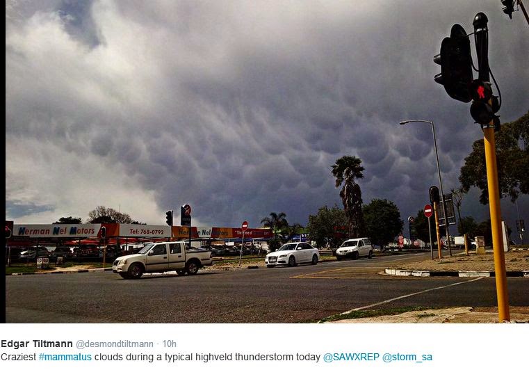
MSBWX National Severe Weather Observations: Mammatus Clouds Observed: Gauteng 20 November 2014
Mammatus, also known as mammatocumulus (meaning "mammary cloud" or "breast cloud"), is a meteorological term applied to a cellular pattern of pouches hanging underneath the base of a cloud. Mammatus are most often associated with the anvil cloud and also severe thunderstorms. When occurring in cumulonimbus, mammatus are often indicative of a particularly strong storm or maybe even a tornadic storm. True to their ominous appearance, mammatus clouds are often harbingers of a coming storm or other extreme weather system. Typically composed primarily of ice, they can extend for hundreds of miles in each direction and individual formations can remain visibly static for ten to fifteen minutes at a time. While they may appear foreboding they are merely the messengers - appearing around, before or even after severe weather. Thankfully no report of any severe weather was received yesterday.
MSBWX General Weather Observations: Cool, warm to hot conditions expected today over parts of SA. Thunderstorms can be expected in parts of Gauteng, Mpumalanga, Limpopo, North West, Free State, and Kwazulu Natal. Drizzle can be expected in the eastern parts of the Eastern Cape this morning. MSBWX National Disaster Observations: ----Nil NSRI National Warnings: ------Nil
Images: Christy Dennis, Jannes van Vuuren, Bonita van Heerden, Andre Nienaber, Las Sutherland, Cornelle Redelinghuys, Mike Dippenaar, Marius Schutte, Mandy Potgieter, Storm Report SA and Algoa FM