I will be leaving for the Eastern Cape early this morning. The area I visit (bush) does not always allow me to update this blog via the Internet as connections are erratic and non existent at times. I have therefor decided not to even try to update this blog during the above period. I apologize for any inconvenience in this regard but this does not happen on a regular basis. (Maybe once a year.)
I will however try to update the @SAWXREP Twitter account and the MSBWX Facebook pages as and when I can establish a reliable Internet connection.
Here are the links to the various accounts:
@SAWXREP Twitter Account
MSBWX Facebook Account
Finally: There are many other great weather sites that can be visited to get the latest weather information and updates. Please feel free to visit them during the above period.
Johan Terblanche
Founder: MSBWX, SAWXREP, SAWDOS, SAWDIS
Mossel Bay
25 July 2014
Friday, 25 July 2014
Thursday, 24 July 2014
Approaching Cold Fronts: Western-, Northern-, Eastern-, and Southern Cape 24 - 27 July 2014
Predictions charts reflect two cold fronts and an upper air trough likely to impact the Western- , Northern-, Southern-
and Eastern Cape during the forecast period. The first cold front is expected to make landfall later today (24 July 2014) while the second front should reach the country late on Saturday (26 July 2014).
The SAWS issued the following warnings:
1. Always the possibility of Severe Weather
2. Moderate to heavy rain
3. Strong to near gale force winds
4. Possible Flooding
5. Cold weather conditions
6. Snowfalls over the high mountains
7. Veld fires
8. Rough Seas
9. Possible storm damage

Severe Weather
This is a well developed and intense weather system that is expected to bring-forth severe weather during the prescribed period. The public are advised that the above conditions (1- 9) can be expected and the necessary precautionary measures need to be taken by the public to minimize the impact of the storm and the subsidiary events.
Moderate to Heavy rain


Moderate to heavy rain is expected in areas of the Western Cape. Heavy rain is expected in Cape Town and surrounding areas, Overberg, Cape Winelands and West Coast. Up to 50mm can be expected in these areas with moderate rain (1- 25mm) over other parts of the Western Cape, Northern Cape and Southern Cape.
Strong to Gale Force Winds
Strong to Gale Force (45 - 75 km/h) gusty North Westerly to Westerly winds can be expected along the West Coast, Western-, Southern and Eastern Cape coastline. Strong to Near Gale Force (35 - 80 km/h) gusty winds can also be expected over parts of the interior. Wind damage is possible in areas.


Possible flooding
Localized flooding is expected in parts of the Cape, Overberg, Cape Winelands and West Coast. Flooding of road and informal settlements is expected in these areas up to Saturday. Flooding, blocked drains and service disruptions can be reported to the Cape Towns City’s Call Centre on 0860 103 089. The local authorities of other regions should be contacted if assistance is needed. In the event of flooding do not try to cross flooded roads, ravines, rivers or streams. Turn around....do not drown!!
Very cold conditions

Very cold conditions (- to 0 Deg/C) is expected behind the cold front as cold air is moving in over the Western-, Southern-, and Northern Cape. Temperatures are expected to drop as the freezing levels lower to 1200 - 1500 meters. With enough moisture and dropping freezing levels snowfalls are expected over parts of the mountains in the Northern-, Western-, and Southern Cape.
Snowfall
Snow is expected over parts of the Northern-, Southern- and Western Cape mountains. Snow Forecast by Snow Report SA:
"It still appears as if the snow fall will be confined to the western half of the country. Nothing for KZN in the latest forecast unfortunately. The cold front is due to make landfall in the WC late on Thursday night, and by Friday morning, we could experience snow falling on the extreme high peaks around Ceres, Worcester and Paarl. Light snow should start extending further inland in the NC regions around Sutherland and Calvinia and possibly just south of Springbok Friday night. Sutherland itself may experience a significant amount of snow from Friday afternoon into the evening. Light snow should continue falling throughout the day, and may extend up into the Cederberg right up to the Citrusdal area. The Swartberg mountain range is also likely to experience some snow at very high elevations Friday night or early hours of Saturday morning."

Raging Veld Fires
Poor to bad visibility can be expected as the risk for run-away veld fires increase with the high fire danger conditions in parts of the Western Cape (Breede River Valley, Cental and Little Karoo) and the interior. 232 fires were detected over the past 24 hours in South Africa. This figure is expected to increase as strong to gale force winds precedes the cold front. Please contact your nearest fire fighting unit, Working on Fire or Local Fire Fighting Service when fires are observed. The earlier a fire is detected to better the chances of extinguishing the fire.
Rough seas
With all the above "ingredients" the sea is surely to be churned up. Rough seas with wave heights of between 4 - 6 meters are expected along the coastal areas of the Northern Cape, Western Cape, Southern Cape and Eastern Cape
Storm Damage
Storm damage is expected as a result of this intense cold front. If you observe any storm damage in your area, please forward details, images and description to @SAWXREP We need to keep the public informed at all times.
Finally: As always do not underestimate any weather system. MSBWX will monitor this front closely and will bring you updates as this system moves across the country.
SAWXREP need your real time weather observations i.o.w. if you observe heavy rain, flooding, strong wind, rough seas, storm damage etc. Please inform the SAWXREP so that we in turn can keep the public informed. Tweet us at @SAWXREP or post on our Facebook timeline by clicking HERE. Do not assume that SAWXREP knows for certain that severe weather has occurred. Help us to spread the word about severe weather and NEVER assume that your weather observation report is not important. SAWXREP would like to hear from you.
- MSBWX + SAWXREP
The SAWS issued the following warnings:
- A gale force NW wind 35kt is expected in places between Table Bay and Cape Agulhas today (Thursday) moderating early Friday morning.
- Heavy rain is expected at times mainly near the mountains of the southern parts of the WestCoast District, Cape Metropole, western parts of the Cape Winelands and Overberg district tonight (Thursday) persisting through to Saturday morning.
- Localized urban flooding is expected in the southern parts of the West Coast District, Cape Metropole, western parts of the Cape Winelands and Overberg district tonight (Thursday) persisting through Saturday.
- Extremely high fire danger conditions can be expected in places over the Breede River Valley, Central and Little Karoo today. (Thursday).
1. Always the possibility of Severe Weather
2. Moderate to heavy rain
3. Strong to near gale force winds
4. Possible Flooding
5. Cold weather conditions
6. Snowfalls over the high mountains
7. Veld fires
8. Rough Seas
9. Possible storm damage
Image: Eumetsat (Click on image for larger view.)
Severe Weather
This is a well developed and intense weather system that is expected to bring-forth severe weather during the prescribed period. The public are advised that the above conditions (1- 9) can be expected and the necessary precautionary measures need to be taken by the public to minimize the impact of the storm and the subsidiary events.
Moderate to Heavy rain
Images: NCEP (Click on images for larger view.)
Moderate to heavy rain is expected in areas of the Western Cape. Heavy rain is expected in Cape Town and surrounding areas, Overberg, Cape Winelands and West Coast. Up to 50mm can be expected in these areas with moderate rain (1- 25mm) over other parts of the Western Cape, Northern Cape and Southern Cape.
Strong to Gale Force Winds
Strong to Gale Force (45 - 75 km/h) gusty North Westerly to Westerly winds can be expected along the West Coast, Western-, Southern and Eastern Cape coastline. Strong to Near Gale Force (35 - 80 km/h) gusty winds can also be expected over parts of the interior. Wind damage is possible in areas.
Images: Windguru and WeatherForecast.com (Click on images for larger view.)
Possible flooding
Localized flooding is expected in parts of the Cape, Overberg, Cape Winelands and West Coast. Flooding of road and informal settlements is expected in these areas up to Saturday. Flooding, blocked drains and service disruptions can be reported to the Cape Towns City’s Call Centre on 0860 103 089. The local authorities of other regions should be contacted if assistance is needed. In the event of flooding do not try to cross flooded roads, ravines, rivers or streams. Turn around....do not drown!!
Image: WeatherForecast.com (Click on image for larger view.)
Very cold conditions (- to 0 Deg/C) is expected behind the cold front as cold air is moving in over the Western-, Southern-, and Northern Cape. Temperatures are expected to drop as the freezing levels lower to 1200 - 1500 meters. With enough moisture and dropping freezing levels snowfalls are expected over parts of the mountains in the Northern-, Western-, and Southern Cape.
Snowfall
Snow is expected over parts of the Northern-, Southern- and Western Cape mountains. Snow Forecast by Snow Report SA:
"It still appears as if the snow fall will be confined to the western half of the country. Nothing for KZN in the latest forecast unfortunately. The cold front is due to make landfall in the WC late on Thursday night, and by Friday morning, we could experience snow falling on the extreme high peaks around Ceres, Worcester and Paarl. Light snow should start extending further inland in the NC regions around Sutherland and Calvinia and possibly just south of Springbok Friday night. Sutherland itself may experience a significant amount of snow from Friday afternoon into the evening. Light snow should continue falling throughout the day, and may extend up into the Cederberg right up to the Citrusdal area. The Swartberg mountain range is also likely to experience some snow at very high elevations Friday night or early hours of Saturday morning."
Image: Snow Report SA (Click on image for larger view.)
Raging Veld Fires
Poor to bad visibility can be expected as the risk for run-away veld fires increase with the high fire danger conditions in parts of the Western Cape (Breede River Valley, Cental and Little Karoo) and the interior. 232 fires were detected over the past 24 hours in South Africa. This figure is expected to increase as strong to gale force winds precedes the cold front. Please contact your nearest fire fighting unit, Working on Fire or Local Fire Fighting Service when fires are observed. The earlier a fire is detected to better the chances of extinguishing the fire.
Rough seas
With all the above "ingredients" the sea is surely to be churned up. Rough seas with wave heights of between 4 - 6 meters are expected along the coastal areas of the Northern Cape, Western Cape, Southern Cape and Eastern Cape
Storm Damage
Storm damage is expected as a result of this intense cold front. If you observe any storm damage in your area, please forward details, images and description to @SAWXREP We need to keep the public informed at all times.
Finally: As always do not underestimate any weather system. MSBWX will monitor this front closely and will bring you updates as this system moves across the country.
SAWXREP need your real time weather observations i.o.w. if you observe heavy rain, flooding, strong wind, rough seas, storm damage etc. Please inform the SAWXREP so that we in turn can keep the public informed. Tweet us at @SAWXREP or post on our Facebook timeline by clicking HERE. Do not assume that SAWXREP knows for certain that severe weather has occurred. Help us to spread the word about severe weather and NEVER assume that your weather observation report is not important. SAWXREP would like to hear from you.
- MSBWX + SAWXREP
Groundwater Deficit Out West

The map above combines data from the satellites of the Gravity Recovery and Climate Experiment (GRACE) with other satellite and ground-based measurements to model the relative amount of water stored in underground aquifers in the continental United States. The wetness, or water content, is a depiction of the amount of groundwater on July 7, 2014, compared to the average from 1948 to 2009. Areas shown in blue have more abundant groundwater for this time of year than comparable weeks over the long-term, while shades of red depict deficits compared to this time of year.
The maps are an experimental product used by the U.S. Drought Monitor and supported by NASA’s Goddard Space Flight Center. The measurements are derived from observations of small changes in Earth’s mass and its gravity field—features that are affected by the movement and storage of water and ice around the planet.
The extent of drought in the American Southwest are reflected well in the GRACE map. California, Nevada, New Mexico, Colorado, Texas, Arizona, Oklahoma, and Nebraska have been suffering from various degrees of long-term drought that has parched the land surface and prevented the replenishing of groundwater below.
However, some other odd juxtapositions appear. The Pacific Northwest states of Oregon and Washington are suffering through raging wildfires, as months of hot weather have dried out forests. But according to the groundwater data, conditions underground are normal to wet—likely a reflection of the long lag between the accumulation and depletion of water underground and the changes in conditions on the surface. Those states had very wet winters, but the heat and dryness of spring and summer have not yet penetrated the underground storage.
References and Related Reading
- National Drought Mitigation Center (2014, July 21) Groundwater and Soil Moisture Conditions from GRACE Data Assimilation. Accessed July 23, 2014.
- NASA (2014, February 25) NASA Responds to California’s Evolving Drought. Accessed July 23, 2014.
- NASA Earth Observatory (2012, September 12) The Gravity of Water.
- U.S. Drought Monitor (2014, July 17) National Drought Summary for July 15, 2014. Accessed July 23, 2014.
- U.S. Geological Survey California Water Science Center (2014, June 23) California Drought Information. Accessed July 23, 2014.
Maps by Chris Poulsen,
National Drought Mitigation Center at the University of
Nebraska-Lincoln, based on data from Matt Rodell, NASA Goddard Space
Flight Center, and the GRACE science team. Caption by Mike Carlowicz.
- Instrument(s):
- GRACE
1 – 3 Day Weather Forecast Summary: Southern Cape/Garden Route Area - Weather-Forecast

Mossel Bay 1 – 3 Day Weather Forecast Summary: Light rain (total 7mm), mostly falling on Fri night. Warm (max 22°C on Thu afternoon, min 10°C on Fri night). Winds increasing (calm on Thu night, fresh winds from the NW by Fri afternoon).
George 1 – 3 Day Weather Forecast Summary:
Light rain (total 7mm), mostly falling on
Fri night. Warm (max 22°C on Thu afternoon, min 10°C on Fri night).
Winds increasing (calm on Thu night, fresh winds from the NW by Fri
afternoon).
Knysna 1 – 3 Day Weather Forecast Summary: Moderate rain (total 11mm), heaviest on Fri night. Warm (max 23°C on Thu afternoon, min 11°C on Fri night). Winds increasing (calm on Thu afternoon, fresh winds from the WSW by Fri night).
Knysna 1 – 3 Day Weather Forecast Summary: Moderate rain (total 11mm), heaviest on Fri night. Warm (max 23°C on Thu afternoon, min 11°C on Fri night). Winds increasing (calm on Thu afternoon, fresh winds from the WSW by Fri night).
Plettenberg Bay 1 – 3 Day Weather Forecast Summary: Moderate rain (total 11mm), heaviest on Fri night.
Warm (max 23°C on Thu afternoon, min 11°C on Fri night). Winds
increasing (calm on Thu afternoon, fresh winds from the WSW by Fri
night).
Oudtshoorn 1 – 3 Day Weather Forecast Summary: Mostly dry. Warm (max 23°C on Thu afternoon, min
7°C on Fri night). Winds decreasing (strong winds from the NW on Fri
afternoon, light winds from the NW by Sat morning).
Riversdale 1 – 3 Day Weather Forecast Summary: Light rain (total 3mm), mostly falling on Fri
afternoon. Warm (max 22°C on Thu afternoon, min 8°C on Fri night). Wind
will be generally light.
- WeatherForecast.com
SA National Severe Weather Observations: 24 July 2014 04h00 SAST - MSBWX
1. Cold Fronts and sharp upper air trough observed: A fairly intense and well developed cold front is approaching the Western Cape and is expected to make landfall later today. The following warnings has been issued by the SAWS:
A full overview of the approaching weather system will be published later this morning on this site.
- MSBWX + SAWXREP
- A gale force NW wind 35kt is expected in places between Table Bay and Cape Agulhas tomorrow afternoon (Thursday) moderating early Friday morning.
- Heavy rain is expected at times mainly near the mountains of the southern parts of the WestCoast District, Cape Metropole, western parts of the Cape Winelands and Overberg district tomorrow night (Thursday) persisting through to Saturday morning.
- Localized urban flooding is expected in the southern parts of the West Coast District, Cape Metropole, western parts of the Cape Winelands and Overberg district tomorrow night (Thursday) persisting through Saturday.
- Extremely high fire danger conditions can be expected in places over the Breede River Valley, Central and Little Karoo tomorrow (Thursday).
A full overview of the approaching weather system will be published later this morning on this site.
- MSBWX + SAWXREP
Weather Satellite Image: 24 July 2014 06h00 SAST - Eumetsat
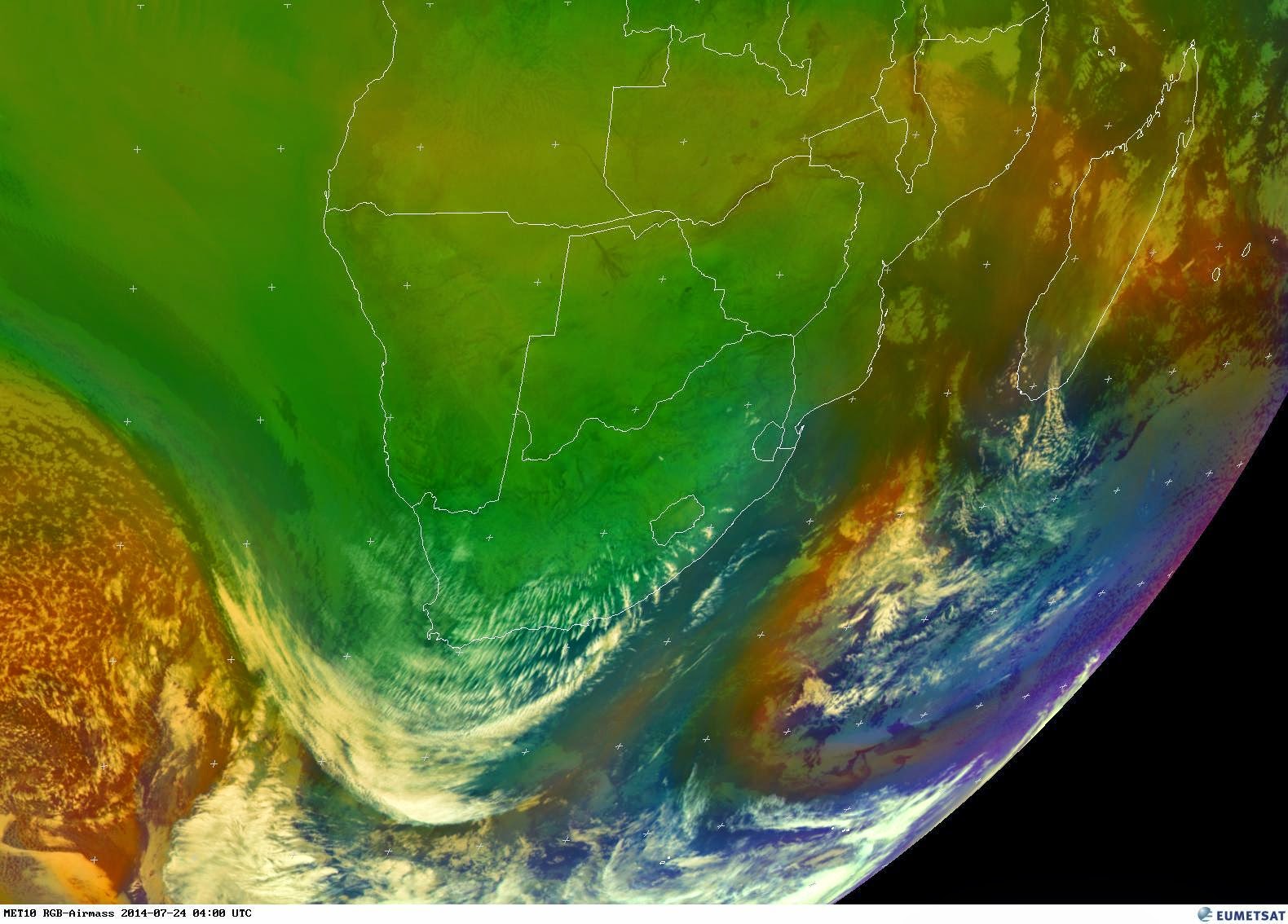
Image: Eumetsat (Click on image for larger view.)
Latest Sea Level Synoptic Chart: 23 July 2014 18H00 - SAWS

Image: SAWS (Click on image for larger view.)
Possible 24 Hour Rainfall Prediction - 1stweather

Image: 1stweather (Click on image for larger view.)
Wednesday, 23 July 2014
You’ve got to see these mammatus clouds
Mammatus clouds are pouch-like protrusions hanging from the undersides of clouds, usually thunderstorm anvil clouds but other types of clouds as well. Composed primarily of ice, these cloud pouches can extend hundreds of miles in any direction, remaining visible in your sky for perhaps 10 or 15 minutes at a time. People associate them with severe weather, and it’s true they can appear around, before or after a storm. Contrary to myth, they don’t continue extending downward to form tornados, but they are interesting in part because they’re formed by sinking air. Most clouds are formed by rising air. Mammatus clouds can appear ominous. But, in a way that’s so common in nature, their dangerous aspect goes hand in hand with a magnificent beauty.

More amazing images available HERE.
- EarthSky
Forging Sulaiman Range

Meanwhile, to the south, the Indian plate was drifting north toward Asia at a rate of about 20 centimeters (8 inches) per year. By 60 million years ago, it had edged close enough to start a slow-motion collision of titanic proportions. Island arcs along India’s leading edge were pushed into Eurasia first, causing the Indian plate to slow down by about half. After another 30 million years, the thicker crust of India proper was smashing into Eurasia at about four centimeters per year. To this day, India still pushes and grinds northward.
The dramatic folding and thickening of continental crust along this line of collision pushed up the arc of mountains known as the Himalayas and Karakoram. These ranges are home to the world’s tallest mountains, but there is another—often overlooked—side to the India-Eurasian collision. While the northern edge of the Indian plate crashed head-on into Eurasia, the western edge sideswiped the Afghan block to the west, pushing up the north-south trending Sulaiman Mountains in what is now Pakistan and Afghanistan.
While not as high as the Himalayas or Karakoram, the Sulaiman range boast some of the most complex tectonic structures in the world. As India moved northward, it began to rotate in a counter-clockwise direction, wrenching the northwestern part of the Indian plate backwards into part of the Eurasian plate. The countervailing forces put the rocks of the Sulaiman range in a unique compressional vice, causing many of its faults to curve and stretch in convoluted ways.
The Advanced Spaceborne Thermal Emission and Reflection Radiometer (ASTER) instrument on NASA’s Terra satellite captured a scene on April 24, 2011, that highlights some of this tectonic complexity. For instance, notice the broad curvature in the southwest-northeast trending folds in the long image below. Note that the combination of visible and near-infrared light used to make this false-color image vegetation appears bright red. The false-color view also helps highlight some of the differences between rock types.

Light-colored rock is limestone; darker-colored rock is sandstone. The presence of this feature is a sign that rock layers near the surface have become disconnected from the underlying rock below and are moving independently it. See the map published in Geomorphology from Space for a detailed look at the location and orientation of the faults.
The lower image shows a plunging syncline east of Zhob, Pakistan. A syncline is a type of fold that often forms in a when plates are pushing together to build mountains. The youngest layers of a syncline are at the center. The rocks making up this syncline are part of the Loralai formation, a series of sedimentary rocks that formed off the northern coast of India in the Jurassic period. Just to the west of this scene, there are dark rocks called ophiolite, which are bits of ocean crust uplifted during the collision. The presence of ophiolite is a clue that separate continental plates were sutured together in this area.

References and Related Reading
- Abdel-Gawad, M. (1970, July 27) The ophiolite belts and suture traces in Pakistan. Geological Society of America Bulletin, 82 (5), 1235-1250.
- Geolog (2013, December 9) Flying over flysch. Accessed June 3, 2014.
- Aitchinson, J. et al. (2006, August 22) When and where did India and Asia collide? Journal of Geophysical Research, 112 (B05423).
- Iqbal, M. & Khan, M. (2012, March 12) Impact of Indo-Pakistan and Eurasian Plates Collision in the Sulaiman Fold Belt, Pakistan. Accessed June 3, 2014.
- Khan, I. & Clyde, W. (2013, July 19) Lower Paleogene Tectonostratigraphy of Balochistan: Evidence for Time-Transgressive Late Paleocene-Early Eocene Uplift. Geosciences, 3 (3), 466-501.
- Robinson, J. (2000) New structural and stratigraphic insights for northwestern Pakistan from field and Landsat Thematic Mapper data. GSA Bulletin, 112 (3), 364-374.
- Shah, S. (1984) The ophiolite belts and suture traces in Pakistan. Geological Bulletin, 17, 113-117.
- Shen-Tu, B. et al. (2012, September 20) Kinematics of active deformation in the Sulaiman Lobe and Range, Pakistan Journal of Geophysical Research Solid Earth, 105 (B6), 13253-13279.
- Short, N. & Blair, R. (1986) Geomorphology from Space: Zinda Pir. Accessed June 4, 2014.
- The Geological Society Continental/Continental: The Himalayas. Accessed June 3, 2014.
- U.S. Geological Survey Himalayas: Two continents collide. Accessed June 3, 2014.
NASA Earth Observatory
image by Robert Simmon and Adam Voiland, with data courtesy of
NASA/GSFC/METI/ERSDAC/JAROS, and the U.S./Japan ASTER Science Team. Caption by Adam Voiland.
- Instrument(s):
- Terra - ASTER - NASA
1 – 3 Day Weather Forecast Summary: Southern Cape/Garden Route Area - Weather-Forecast
Mossel Bay 1 – 3 Day Weather Forecast Summary: Some drizzle, heaviest during Fri night. Warm (max 23°C on Thu afternoon, min 9°C on Fri night). Winds increasing (calm on Thu night, strong winds from the NW by Fri morning).
George 1 – 3 Day Weather Forecast Summary: Some drizzle, heaviest during Fri night. Warm (max
23°C on Thu afternoon, min 9°C on Fri night). Winds increasing (calm on
Thu night, strong winds from the NW by Fri morning).
Knysna 1 – 3 Day Weather Forecast Summary: Light rain (total 6mm), mostly falling on Fri night. Warm (max 24°C on Thu afternoon, min 11°C on Fri night). Winds increasing (calm on Thu afternoon, strong winds from the NW by Fri morning)
Knysna 1 – 3 Day Weather Forecast Summary: Light rain (total 6mm), mostly falling on Fri night. Warm (max 24°C on Thu afternoon, min 11°C on Fri night). Winds increasing (calm on Thu afternoon, strong winds from the NW by Fri morning)
Plettenberg Bay 1 – 3 Day Weather Forecast Summary:
Light rain (total 6mm), mostly falling on
Fri night. Warm (max 24°C on Thu afternoon, min 11°C on Fri night).
Winds increasing (calm on Thu afternoon, strong winds from the NW by Fri
morning).
Oudtshoorn 1 – 3 Day Weather Forecast Summary: Mostly dry. Warm (max 23°C on Thu afternoon, min
6°C on Fri night). Winds increasing (light winds from the NNE on Wed
morning, strong winds from the NW by Fri morning).
Riversdale 1 – 3 Day Weather Forecast Summary: Light rain (total 5mm), mostly falling on Fri
night. Warm (max 23°C on Thu afternoon, min 8°C on Fri night). Winds
increasing (calm on Thu night, fresh winds from the W by Fri afternoon).
- WeatherForecast.com
SA National Severe Weather Observations: 23 July 2014 04h00 SAST - MSBWX
There are no severe weather observation reports today.
Weather Satellite Image: 23 July 2014 05h00 SAST - Eumetsat

Image: Eumetsat (Click on image for larger view.)
Latest Sea Level Synoptic Chart: 23 July 2014 18H00 - SAWS

Image: SAWS (Click on image for larger view.)
Possible 24 Hour Rainfall Prediction - 1stweather

Image: 1stweather (Click on image for larger view.)
Tuesday, 22 July 2014
NOAA honors New York farmer for 84 years as volunteer weather observer
When Richard Hendrickson took his first reading as a cooperative observer for the National Weather Service, Herbert Hoover was president. The year was 1930. Since then the Bridgehampton, N.Y., farmer has filed twice daily reports, tallying more than 150,000 individual weather observations - playing a critical role in building our nation's climate history.
On July 27, Hendrickson, age 101, will receive an award for his long standing service -- 84 years -- to the nation. Since Hendrickson is first in the history of the program to serve for more than eight decades, the new 80-year service award will be named in his honor. - NOAA
MSBWX: Now this is a great achievement and service to the community. Richard must be one of the oldest active weather observers in the world. Congrats Richard and thank you for the service you rendered to your community and the USA.
Coastlines of the Southern Baltic Sea

In this fleeting view from June 15, 2014, the coast of southern Norway is outlined near the horizon. The brightest reflection highlights the narrow sea passage known as the Skagerrak—revealing the thin tip of Denmark. Numerous small lakes in southern Sweden appear at image center, and scattered clouds cast complex shadows on the southern Baltic Sea. The sweeping curves of the sand spit on the Polish coast and the long barrier islands on the Russian coast appear in the foreground, at the edge of the Sun’s reflection disc. A more detailed image of these barrier islands is available here.
Astronaut photograph ISS040-E-12110
was acquired on June 15, 2014, with a Nikon D3S digital camera using an
80 millimeter lens, and is provided by the ISS Crew Earth Observations
Facility and the Earth Science and Remote Sensing Unit, Johnson Space
Center. The image was taken by the Expedition 40 crew. It has been cropped and enhanced to improve contrast, and lens artifacts have been removed. The International Space Station Program supports the laboratory as part of the ISS National Lab
to help astronauts take pictures of Earth that will be of the greatest
value to scientists and the public, and to make those images freely
available on the Internet. Additional images taken by astronauts and
cosmonauts can be viewed at the NASA/JSC Gateway to Astronaut Photography of Earth. Caption by M. Justin Wilkinson, Jacobs at NASA-JSC.
- Instrument(s):
- ISS - Digital Camera - NASA
1 – 3 Day Weather Forecast Summary: Southern Cape/Garden Route Area - Weather-Forecast
Mossel Bay 1 – 3 Day Weather Forecast Summary: Mostly dry. Warm (max 23°C on Thu afternoon, min 14°C on Tue morning). Wind will be generally light.
George 1 – 3 Day Weather Forecast Summary: Mostly dry. Warm (max 23°C on Thu afternoon, min 14°C on Tue morning). Wind will be generally light.
Knysna 1 – 3 Day Weather Forecast Summary: Mostly dry. Warm (max 24°C on Thu afternoon, min 15°C on Tue night). Wind will be generally light.
Knysna 1 – 3 Day Weather Forecast Summary: Mostly dry. Warm (max 24°C on Thu afternoon, min 15°C on Tue night). Wind will be generally light.
Plettenberg Bay 1 – 3 Day Weather Forecast Summary: Mostly dry. Warm (max 24°C on Thu afternoon, min 15°C on Tue night). Wind will be generally light.
Oudtshoorn 1 – 3 Day Weather Forecast Summary: Mostly dry. Warm (max 24°C on Thu afternoon, min 13°C on Tue night). Wind will be generally light.
Riversdale 1 – 3 Day Weather Forecast Summary: Mostly dry. Warm (max 23°C on Thu afternoon, min 13°C on Tue night). Wind will be generally light.
- WeatherForecast.com
SA National Severe Weather Observations: 22 July 2014 04h00 SAST - MSBWX
There are no severe weather observation reports today.
Weather Satellite Image: 22 July 2014 06h00 SAST - Eumetsat

Image: Eumetsat (Click on image for larger view.)
Latest Sea Level Synoptic Chart: 22 July 2014 00H00 - SAWS
The SAWS webpage does not display any sea level synoptic chart this morning. The following message appear.

Possible 24 Hour Rainfall Prediction - 1stweather

Image: 1stweather (Click on image for larger view.)
Monday, 21 July 2014
South Africa at night as seen from the ISS: Cape Town to Johannesburg

Image: Astro Reid Wiseman, NASA (Click on image for larger view.)
Looking Back from Apollo 11


These two photographs were taken by the crew on their outbound journey from Earth to the Moon. Apollo 11 launched from Cape Canaveral at 9:32 a.m. on July 16, 1969, and these photos were captured that day. The top view shows the full disk of Earth, with bits of California, the Pacific Northwest coast, and Alaska peeking through the cloud cover in a scene otherwise dominated by the Pacific Ocean. The second, closer view shows more of the western United States and Canada, with the Rocky Mountains filling much of the center of the scene and the Arctic ice cap at the top.
Unless you spend a lot of time looking at images from space—a pasttime that was in its infancy in the late 1960s—the view can be mysterious and disorienting sometimes. Reading through the transcripts of Apollo 11 communications, we can get some sense of the wonder, disorientation, and awe that Buzz Aldrin, Michael Collins, and Neil Armstrong must have felt while looking for navigation points or for simple beauty shots of their planet.
About 51 minutes after launch, the conversation centered around lights in Earth’s atmosphere:
Collins: Look at those bright ones down here.
Aldrin: Lightning! Is that lightning out your window?
Armstrong: No, I haven't seen any lightning.
Aldrin: Hell, that must be lightning. Either that or it's the atmosphere.
Armstrong: I just saw something. Maybe it is the atmosphere. They said that Borman's [crew] could see it. They couldn't hear it, but they could see it alright.
About 30 minutes later, Collins noted: “It looks like trees and a forest or something. Looks like snow and trees. Fantastic. I have no conception of where we're pointed or which way we are, but it's a beautiful low-pressure cell out here.”
Ten hours into the flight, Aldrin and astronaut Charlie Duke (working communications from Mission Control in Houston, Texas), had a conversation that sounds like a description of the images above. It was followed by some commentary between Armstrong and Duke.
Aldrin: Hey, Charlie, I can see the snow on the mountains out in California, and it looks like LA doesn’t have much of a smog problem today.
Duke: Roger, Buzz. Copy. Looks like there’s a good view out there then.
Aldrin: Charlie, with the monocular, I can discern a definite green cast to the San Fernando Valley.
Duke: How’s Baja California look, Buzz?
Aldrin: Well, it’s got some clouds up and down it, and there’s a pretty good circulation system a couple of hundred miles off the west coast of California....Okay, Houston. You suppose you could turn the Earth a little bit so we could get a little bit more than just water?
Duke: Roger, 11. I don't think we got much control over that. Looks like you'll have to settle for the water.
To learn more about NASA’s celebration of the 45th anniversary of Apollo 11, click here.
Reference
- NASA History Division (2011, March 29) The Apollo 11 Flight Journal. Accessed July 20, 2014.
Astronaut photograph AS11-36-5339
was acquired on July 16, 1969, with a Hasselblad camera using a 250
millimeter lens. It is provided by the ISS Crew Earth Observations
Facility and the Earth Science and Remote Sensing Unit, NASA Johnson
Space Center. Astronaut photograph AS11-36-5302
was acquired on July 16, 1969, with a Hasselblad camera using an 80
millimeter lens and is provided by the Lunar and Planetary Institute.
Both photos have been cropped and enhanced to improve contrast, and lens
artifacts have been removed. Additional images taken by astronauts and
cosmonauts can be viewed at the NASA/JSC Gateway to Astronaut Photography of Earth. Caption by Mike Carlowicz.
- Instrument(s):
- Apollo - NASA
1 – 3 Day Weather Forecast Summary: Southern Cape/Garden Route Area - Weather-Forecast
Mossel Bay 1 – 3 Day Weather Forecast Summary: Mostly dry. Warm (max 20°C on Wed afternoon, min 12°C on Mon morning). Wind will be generally light.
George 1 – 3 Day Weather Forecast Summary: Mostly dry. Warm (max 20°C on Wed afternoon, min 12°C on Mon morning). Wind will be generally light.
Knysna 1 – 3 Day Weather Forecast Summary: Mostly dry. Warm (max 21°C on Wed afternoon, min 13°C on Mon morning). Wind will be generally light.
Knysna 1 – 3 Day Weather Forecast Summary: Mostly dry. Warm (max 21°C on Wed afternoon, min 13°C on Mon morning). Wind will be generally light.
Plettenberg Bay 1 – 3 Day Weather Forecast Summary: Mostly dry. Warm (max 21°C on Wed afternoon, min 13°C on Mon morning). Wind will be generally light.
Oudtshoorn 1 – 3 Day Weather Forecast Summary: Mostly dry. Very mild (max 19°C on Wed afternoon, min 10°C on Mon morning). Wind will be generally light.
Riversdale 1 – 3 Day Weather Forecast Summary: Mostly dry. Warm (max 21°C on Wed afternoon, min 10°C on Mon morning). Wind will be generally light.
- WeatherForecast.com
SA National Severe Weather Observations: 21 July 2014 04h00 SAST - MSBWX
There are no severe weather observation reports today.
Weather Satellite Image: 21 July 2014 06h00 SAST - Eumetsat

Image: Eumetsat (Click on image for larger view.)
Latest Sea Level Synoptic Chart: 21 July 2014 00H00 - SAWS
The SAWS webpage does not display any sea level synoptic chart this morning. The following message appear.

Possible 24 Hour Rainfall Prediction - 1stweather

Image: 1stweather (Click on image for larger view.)
Sunday, 20 July 2014
Final Update/Summary - Cold Fronts: Western-, Northern-, Eastern-, and Southern Cape 16 - 21 July 2014
We still have cold air in circulation, rough seas and strong wind over parts of South Africa. See: http://mosselbayweather.blogspot.com/2014/07/sa-national-severe-weather-observations_20.html

This is what MSBWX expected from these cold fronts:
1. Always the possibility of Severe Weather
2. Moderate to heavy rain
3. Strong to near gale force winds
4. Possible Flooding
5. Cold weather conditions
6. 10% chance of light snowfalls over the high mountains
7. Veldfires
8. Rough Seas (4 - 6m today but increase to >9m along the EC Coast by late tomorrow and Saturday)
9. Possible storm damage
10. Bergwind conditions ahead of the first cold front
Herewith some feedback:
Always the possibility of Severe Weather:
N3 Toll Concession@N3Route #VanReenenPass: W Station Alert: Wind gust threshold reached at 141km/h.
Moderate to heavy rain :
18 July 2014 - Kirstenbosch 43mm, Paarl 28mm, Molteno Reservoir (CT) 25mm, Bellville 23mm, Franschhoek 23mm, Jonkershoek 23mm, SAAO Observatory 22mm, Cape Town Airport (W/O) 21mm, Tulbagh 20mm, etc. Many other places in the SW-Cape received between 10-20mm. Also of note were Nieuwoudtville (NC) 14mm and Springbok (NC) 13mm. - SAWS
Strong to near gale force winds:

Possible Flooding :
Cape Town Flooding - Cape Town FMS


Cold weather conditions:
No reports of very intense cold weather conditions have been received although light snowfalls were reported.
10% chance of light snowfalls over the high mountains:
We have a little snow on the ground at Solaris just outside Sutherland this morning. :)

Mossel Bay Weather Observation shared Snow Report SA's status.

Veldfires:


Betty's Bay Fire - 16 July ·


Letaba Fire Protection Accociation - An aerial photo taken by our Spotter Pilot, Siem Venter, of the fire up in Haenertsburg.
 More images: https://www.facebook.com/letabafire?fref=ts
Many other reports of fires received. See our Facebook and Twitter Pages.
Rough Seas (4 - 6m today but increase to >9m along the EC Coast by late tomorrow and Saturday):

See video: https://www.facebook.com/photo.php?v=816546501697193
Possible storm damage:
Velf fires destroy grazing and houses
Wind damage trucks on the N3
Bergwind conditions ahead of the first cold front :
The high minimum temperatures that led to some record highs overnight, were a result of warming from a North Westerly flow of warm air from the interior.
These dry Berg winds warm the temperature up at approximately 3 degrees Celsius per 1000ft of descent from the escarpment to the coast. More at Weather Guru: https://www.facebook.com/pages/Weather-Guru/192566374124112
Once again this cold front has shown that we should never underestimate the weather. As I indicated before this event, there is always the possiblity of severe weather occurring during this event.
Finally: I would like to thank all the members of public, private sector, radio amateurs, the media and real time observers who send photos, information and reports about this event. With the information received we kept the public informed. I am overwhelmed by the response.
Once again thank you for the support and service. I am looking forward to your continued support. With your help we can render a free service to the public and hopefully contribute to save and better the lives of those in need.
Johan Terblanche
Founder: MSBWX, SAWXREP, SAWDOS, SAWDIS
Mossel Bay
20 July 2014
This is what MSBWX expected from these cold fronts:
1. Always the possibility of Severe Weather
2. Moderate to heavy rain
3. Strong to near gale force winds
4. Possible Flooding
5. Cold weather conditions
6. 10% chance of light snowfalls over the high mountains
7. Veldfires
8. Rough Seas (4 - 6m today but increase to >9m along the EC Coast by late tomorrow and Saturday)
9. Possible storm damage
10. Bergwind conditions ahead of the first cold front
Herewith some feedback:
Always the possibility of Severe Weather:
N3 Toll Concession
Moderate to heavy rain :
18 July 2014 - Kirstenbosch 43mm, Paarl 28mm, Molteno Reservoir (CT) 25mm, Bellville 23mm, Franschhoek 23mm, Jonkershoek 23mm, SAAO Observatory 22mm, Cape Town Airport (W/O) 21mm, Tulbagh 20mm, etc. Many other places in the SW-Cape received between 10-20mm. Also of note were Nieuwoudtville (NC) 14mm and Springbok (NC) 13mm. - SAWS
Strong to near gale force winds:
Image: Wind ripping Tautliners apart in Van Reenens - Truck and Cargo
- Gale Force Wind - N3 Toll Concession
@N3Route#VanReenenPass: W Station Alert: Wind gust threshold reached at 141km/h. - Strong Wind - SA Weather Reports @SAWXREP · 12h15 SAST Mossel Bay WX Update: WNW wind gusting at 36 km/h at times. 6/8 Cloud cover. Temp 20 Deg/C Baro: 1006 mb
- 2014 Aerobatic Championships- MSB Airfield WX Update: Wind Speed: 18 - 49 km/h, Wind NNW, Temp 19.8 Deg/C Baro 1005 mb CB Alt 990Ft Hum 86%
Possible Flooding :
Cape Town Flooding - Cape Town FMS
Cold weather conditions:
No reports of very intense cold weather conditions have been received although light snowfalls were reported.
10% chance of light snowfalls over the high mountains:
Snow Report SA
@SnowReportSA
Mossel Bay Weather Observation shared Snow Report SA's status.
17 July - The first report of snow is in from the Matroosberg Private Nature Reserve.
It is snowing down at their reception, but is not building up at ground
level as yet. There is bound to be more further up the mountain!
Veldfires:
- Most fires detected in 24 hours during this event in South Africa : 463
- VWS Wildfires
@vwsfires
·
Sad news as
#BettysBay#wildfire destroys two house overnight (via@news24) http://www.news24.com/SouthAfrica/News/Fire-destroys-2-houses-in-Bettys-Bay-20140717 …
Betty's Bay Fire - 16 July ·  · Taken at Betty's Bay
On
Wednesday night 12 hours of blazing fire was being spread by gale force
winds. The fire started around 7pm and two houses have been claimed by
the fire. Others have been seriously damaged.
http://whalecoastfm.co.za/
Photos by Melissa Jade Bradley.
http://whalecoastfm.co.za/
Photos by Melissa Jade Bradley.
- Suzanne Elizabeth Wille + Christine Webber - Wildfire destroys 5 houses at Stone's Hill, Grahamstown.
Letaba Fire Protection Accociation - An aerial photo taken by our Spotter Pilot, Siem Venter, of the fire up in Haenertsburg.
Many other reports of fires received. See our Facebook and Twitter Pages.
Rough Seas (4 - 6m today but increase to >9m along the EC Coast by late tomorrow and Saturday):
See video: https://www.facebook.com/photo.php?v=816546501697193
Possible storm damage:
Velf fires destroy grazing and houses
Wind damage trucks on the N3
Bergwind conditions ahead of the first cold front :
The high minimum temperatures that led to some record highs overnight, were a result of warming from a North Westerly flow of warm air from the interior.
These dry Berg winds warm the temperature up at approximately 3 degrees Celsius per 1000ft of descent from the escarpment to the coast. More at Weather Guru: https://www.facebook.com/pages/Weather-Guru/192566374124112
Once again this cold front has shown that we should never underestimate the weather. As I indicated before this event, there is always the possiblity of severe weather occurring during this event.
Finally: I would like to thank all the members of public, private sector, radio amateurs, the media and real time observers who send photos, information and reports about this event. With the information received we kept the public informed. I am overwhelmed by the response.
Once again thank you for the support and service. I am looking forward to your continued support. With your help we can render a free service to the public and hopefully contribute to save and better the lives of those in need.
Johan Terblanche
Founder: MSBWX, SAWXREP, SAWDOS, SAWDIS
Mossel Bay
20 July 2014
Subscribe to:
Comments (Atom)